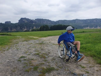
Wheelchair tour "Through the Affensteine"

8.00 km long
Round trip
Difficulty: difficult
Condition: very difficult
Great panorama
Hiking
  • 2:18 h
  • 8.00 km
  • 162 m
  • 162 m
  • 148 m
  • 292 m
  • 144 m
  • Start: Parking lot "Beuthenfall", Kirnitzschtal
  • Destination: Parking lot "Beuthenfall", Kirnitzschtal
This tour leads to the impressive rock formations of the Affensteine and Schrammsteine. It is very demanding in terms of fitness and requires persistent helpers for support.

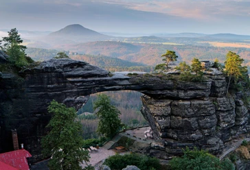
The Elbe Sandstone Mountains show off one of their most impressive sides in the so-called Affensteine. The name of these rugged rock faces is derived from "Auff", an old name for the eagle owl that also lives here. Some of the most important climbing peaks in Saxon Switzerland can be found here as well as in the Schrammsteine, which you also pass on this tour. The Bloßstock, Brosinnadel and Falkenstein, on whose walls free climbing was born in 1864, can be seen from the trail. This strenuous hike is therefore highly recommended for active guests in wheelchairs.

Good to know

Pavements

Street (17%)
Asphalt (33%)
Gravel (10%)
Trail (40%)

Best to visit

suitable
Depends on weather

Directions

From Beuthenfall in the Kirnitzschtal valley, the trail first climbs very steeply for 200m on a wide path. There are some small sandstone drainage channels to cross, but these are not major obstacles. After the bend in the path, the path slopes downwards and climbs only moderately. At the next crossroads, near a forest hut, turn right. The path now climbs steeply again until, after approx. 650m, we reach the rocks of the Lange Horn with the summit of the Bloßstock on the left. We now continue along the wide hiking trail, also known as the "Untere Affensteinpromenade", in the direction of the Schrammsteine. Although there are short ascents and descents from time to time, we make good progress on the firm and finely gritted surface. Beautiful views of some of the rock formations of the Affensteine make the hike quite varied. Formerly sandy sections of the path have now been paved with sandstone. On the main path, we pass a number of branches with such evocative names as "Wild Hell" and "Great Cathedral", although these are not accessible in a wheelchair. Passing the Lorenzlöchern, we finally reach a large crossroads below the Schrammsteine, where we branch off slightly downhill to the Wildwiese. Our path now joins the Wenzelweg, which we follow turning right and soon pass the rest area with the two huts at the Wildwiese. The wide forest path - even asphalted on the steepest section - then leads us back to the Kirnitzschtal valley via Nassen Grund.Unfortunately, it is not possible to avoid walking the last 1.4 km in the Kirnitzschtal valley to Beuthenfall on the road, as the rafting trail is not suitable for wheelchair users. However, with a narrow wheelchair and helpers (for the non-barrier-free entry and exit), it is possible to take the historic Kirnitzschtalbahn to the destination as an alternative.

Tour information

  • Cultural Interesting

  • Loop Road

  • Stop at an Inn

  • Suitable for Pushchair

Directions & Parking facilities

Coming from Pirna, take the B172 via Königstein in the direction of Bad Schandau. Cross the Elbe in Bad Schandau and take the first left after the market square in the direction of Hinterhermsdorf. Drive through the Kirnitzschtal valley to the Beuthenfall parking lot.

Parking lot Beuthenfall, Kirnitzschtal (subject to charge)

Arrival/ Departure:

Car, bus line 241 or Kirnitzschtalbahn to Beuthenfall parking lot

Further information

Additional information

The tour leads entirely along wide forest paths, which are also signposted as "Cycle route in the National Park". There are no refreshment stops along the route, but there is a large rest area at the Wildwiese.

There is a freely accessible mobile toilet for wheelchair users at the "Nasser Grund" parking lot in the Kinitzschtal valley.

Author´s Tip / Recommendation of the author

If necessary, this tour can also be done on a handbike, as it leads exclusively on forest roads and paths which are signposted as cycle routes in the national park.

Safety guidelines

Please note: in the Saxon Switzerland National Park, only marked trails may be used in the core zone! Fines may be imposed for non-compliance.

Path markings

Nearby