Hike from Kurort Rathen via the Bastei to Stadt Wehlen


- 3:06 h
- 10.58 km
- 320 m
- 320 m
- 112 m
- 318 m
- 206 m
- Start: Kurort Rathen
- Destination: Stadt Wehlen
Kurort Rathen train station - Amselsee - Amselgrund - Schwedenlöcher - Bastei - Neurathen rock castle - Fremdenweg (green line and red dot) - Stone Table - Schwarzbergweg - Stadt Wehlen - train station - Kurort Rathen

Good to know
Best to visit
Directions
It starts at the Kurort Rathen train station, which is well suited for both travelers using public transportation and drivers, as there is a large public parking lot available. At the beginning of our route, we experience a true rarity – the historic reaction ferry in Kurort Rathen, with which we cross the Elbe. Upon arriving in Kurort Rathen, we follow the signs through the small village towards Amselsee and can enjoy the tranquility of this car-free zone. Just a few hundred meters later, we already see the boat dock. On the Amselsee, which was formed by damming the Grünbach, a romantic gondola ride is recommended. This is possible from April to October.
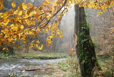
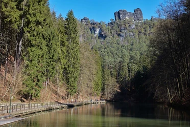
After this, we continue our hike along the Amselgrund. About 1 km from the boat dock, a left turn leads us into the Schwedenlöcher. Now we go up over 700 steps, numerous iron ladders, and about 160 meters of elevation towards the Bastei. We follow the signs to the Bastei plateau. Arrived at the landmark of Saxon Switzerland, we can now enjoy the view offered to us. From numerous viewpoints, a panorama opens up with all the large table mountains, such as the Lilienstein or the Königstein, the Schrammsteine chain, and the Großer Winterberg. In good weather, we can even see as far as the Bohemian Switzerland and the Ore Mountains.
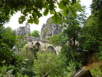
After enjoying these views, we walk over the 76.5-meter-long Bastei Bridge, which spans the Wehlgrund, and reach the Neurathen rock castle. In the Neurathen rock castle, we see remains of a medieval fortress. After the visit, we walk back over the Bastei Bridge and then a short distance (about 250 m) along the street before turning left onto the Fremdenweg (green line and red dot). We walk just under a kilometer before reaching the Stone Table. Here we have a good opportunity to take a short break, as the table, on which people already dined in 1710, is still present.
After this short rest, we set off on the Schwarzbergweg, which is also part of the Malerweg. This leads us about 2 kilometers downhill until we arrive in Stadt Wehlen, where we have the opportunity to order a small meal or a coffee. In the last part of the hike, we only have to cross with the Elbe ferry and finally take the S-Bahn from the nearby station back to Kurort Rathen.
Tour information
Cultural Interesting
Loop Road
Stop at an Inn
Equipment
Surefootedness and sturdy footwear required
Directions & Parking facilities
Motorway A17, exit Pirna, B172 towards Bad Schandau to the roundabout behind Struppen settlement, there towards Kurort Rathen. Parking lots by the Elbe. Here crossing by passenger ferry
Parking lot - Elbe parking lot
Arrival / Departure:
S-Bahn S1, either stop "Kurort Rathen" steamship (ferry crossing necessary) or "Stadt Wehlen"
Additional information
Hike along well-known attractions of Saxon Switzerland, ascent and descent over steps, visit to the Bastei and the Neurathen rock castle, dining opportunities available, return by public transport
Literature
Order now: hiking guides
Safety guidelines
possible all year round (except in snow and ice conditions; gondolas on the Amselsee only from April to October)
Please note: in the Saxon Switzerland National Park, only marked paths may be used in the core zone! Violations may result in fines.
Map
Buy here: hiking maps
Nearby


Download GPX file