Handbike Tour "To the Big and Little Zschirnstein"


- 5:50 h
- 22.56 km
- 316 m
- 314 m
- 119 m
- 421 m
- 302 m
- Start: Hiking Parking Lot in Krippen
- Destination: Hiking Parking Lot in Krippen
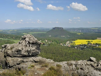
This tour involves a significant elevation gain: from about 122 m above sea level on the Elbe to 426 m above sea level near the Großer Zschirnstein, the highest table mountain in the Saxon part of the Elbe Sandstone Mountains. While there are frequent beautiful views of the surrounding area at the start in the Elbe Valley and above Reinhardtsdorf-Schöna, most of the route leads through the forest and later back to the Elbe through the narrow Krippenbach Valley. Apart from the Elbe Cycle Route, the route alternates between lightly trafficked public side roads and forest trails that are closed to public traffic and designated as bike paths. Anyone using a handbike without motor assistance should be in good physical condition!

Good to know
Pavements
Best to visit
Directions
Shortly after passing the first houses in Schmilka-Hirschmühle, a small alley branches off to the right into the Hirschgrund, where we now turn. Immediately after passing through the underpass beneath the railroad tracks, the road steepens to a maximum gradient of 12%. Currently (as of late 2025), this section is closed to motor vehicles because a devastating storm caused extensive damage. However, a temporary wooden walkway allows pedestrians and cyclists to cross the destroyed section of the road. After about one kilometer, the gradient levels off, and soon we reach the main road from Reinhardtsdorf to Schöna
.
Here, we must turn left and tackle another short climb with a gradient of up to 12%. Initially following the main road, we turn slightly right in the center of Schöna (marked by a sandstone sculpture) onto a granite-paved street, on which we now leave the village as the road climbs. After the last houses, the bumpy cobblestone ends, and the route continues on smooth asphalt, climbing gently toward the Reuterhof settlement.
At a sharp right-hand curve—where the turning area and parking lot are located—the route now leads diagonally left, briefly uphill, and then past the “Waldschänke” (no regular opening hours!) into the forest. This is where the asphalt ends. After a relatively flat section about 500 m long, we turn slightly to the right onto the Marktweg, which is marked with a yellow line. This path takes us to the large intersection below the Großer Zschirnstein, where the dead-straight, approximately 2 km-long stretch climbs over several humps—sometimes more, sometimes less strenuously. The gradient of the gravel dirt road here reaches up to 10% in places, though the steepest sections at least have an old asphalt surface. Once you reach the intersection after this seemingly endless climb, you’ll find the so-called “Kalkbude” on your right—a shelter that’s perfect for a break. This is where the most grueling part of the tour is behind you.
After we’ve turned left at a right angle, the trail continues to climb slightly, but not for much longer. As soon as we’ve finally passed the “Zschirnstein-Biwak” on the right side of the trail, the trail descends for 2.5 km along the Gliedenbachweg and then, from the junction with the Krippenbachtal at a large intersection, continues along the Krippenbach in the direction of its flow back toward the Elbe Valley. Here we’re back on a forest road with old asphalt, from which we finally switch to the road between Kleingießhübel and Cunnersdorf after another 2.5 km.
There, we stay in the valley and ride past the Forstmühle mill, continuing on to the village of Kleingießhübel, though we only pass by the very first houses at the bottom of the valley. A final short and gentle climb takes us back into the narrowing valley, where we soon roll downhill at a brisk pace toward the Elbe toward Krippen. In Krippen, too, we continue along the valley road and soon reach the starting point of our ride at the junction with the Elbe Cycle Route.
Tour information
Loop Road
Directions & Parking facilities
From Pirna, take the B172 toward Bad Schandau. Before the Elbe Bridge at the entrance to Bad Schandau, turn right toward Krippen.
S-Bahn Line S1 to Krippen Station
Literature
Author´s Tip / Recommendation of the author
Safety guidelines
Nearby


Download GPX file