Bielatal: Through the bizarre rock formations with many scenic overlooks


- 3:45 h
- 9.38 km
- 308 m
- 308 m
- 331 m
- 437 m
- 106 m
- Start: Blast Furnace Parking Lot or Bielatal, Brausenstein Bus Stop
- Destination: Blast Furnace Parking Lot or Bielatal, Brausenstein Bus Stop
Parking Lot/Bus Stop Bielatal, Brausenstein - Memorial Grove - Bertablick - Kleine Bastei - Rosengarten - Kaiser-Wilhelm-Feste - Felsengasse (Hercules Columns) - Großvaterstuhl - Ottomühle - Dachsensteinbaude - Johanniswacht - Sachsenstein - Historic Blast Furnace - Parking Lot/Bus Stop Bielatal, Brausenstein

Good to know
Pavements
- Street (11%)Asphalt (1%)Gravel (6%)Trail (13%)Path (69%)
Best to visit
- suitableDepends on weather
Directions
- The hike begins at the parking lot by the blast furnace or at the Rosenthal-Bielatal Brausenstein bus stop. Directly across from the parking lot stands a large, restored blast furnace that is open to visitors. The trail starts on the quiet road heading toward Schweizermühle. About 300 meters after crossing a small bridge, turn left and head uphill toward Bertablick and Kleine Bastei (signpost: yellow dot). These two beautiful lookout points overlooking Schweizermühle are the first highlights of the tour.
The Schweizermühle district was once an old hammer mill complex and flourished in the 19th century as a cold-water sanatorium. In 1912, the Maggi Group acquired the bankrupt facility and used the grounds as a vacation home for its employees. It served as a tuberculosis sanatorium until 1962 and thereafter as a retirement home. Since the political transition, the ravages of time have taken their toll on the once-magnificent and now-vacant buildings.
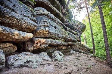
It’s definitely worth taking a detour to the mystical memorial grove, which branches off immediately after the Kleine Bastei viewpoint. The trail continues downhill through the rose garden. If you’d like, you can also stop first to enjoy the view from the Wetterfahnenfels, though it’s a bit overgrown. From the rose garden, follow the path uphill, which leads back to the road. Follow this road downhill for a short distance, then turn left, following the signpost (yellow dot) over a small bridge to re-enter the rocky landscape.
Once at the top, there are a few things to discover. Whether it’s the many boundary stones adorned with crowns, a romantic ruin reminiscent of Rapunzel, or the Kaiser-Wilhelm-Feste—a crenellated bastion tower built in 1880 as a lookout point.
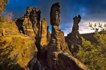
Shortly afterward, a trail branches off to the right and leads downhill between the rocks. A rocky path with iron steps takes you up a few meters in elevation again. Here, the next spectacular view awaits: the Hercules Pillars. It’s hard to believe that climbers entrust their lives to these delicate rock formations. Green triangles point to lookout points, so it’s worth veering off the trail now and then to enjoy the view.
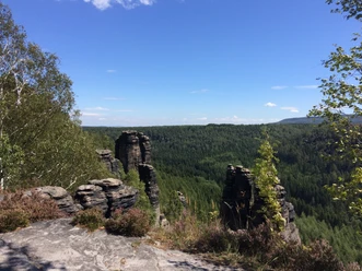
The yellow dot trail marker leads past additional rocky sections, up a narrow path, and continues to the right toward Mühlweg, offering scenic views along the way. From there, you can include a detour to the Großvaterstuhl viewpoint. The Mühlweg leads down into the valley; you’re now halfway through the hike.
The places to stop along the way—the traditional Ottomühle restaurant or the Dachsensteinbaude snack bar—are perfect for a bite to eat before continuing on to the next climb.
Follow the road along the Biela for about 200 meters, then turn left onto the Kerbensteig (marked with a green dot). The next summit awaits: the Johanniswacht, with its stunning view across the Biela Valley to the Kaiser-Wilhelm-Feste on the opposite side. After reaching the summit of the Sachsenstein a little later, the trail now follows the yellow dot to the Nachbar viewpoint—the last rock formation to be climbed on this tour.
To get there, head back downhill to the Sophien-Quelle and from there follow the signpost marked “AP Nachbar” (difficult ascent). As early as 1825, Carl Merkel wrote: “If time and physical strength permit, we will climb the... Herr Nachbar, a magnificent rocky outcrop with a surprising view.”
Finally, the trail leads back downhill. At the forest chapel, the Poststeig trail runs to the left (be careful not to miss the turnoff). Follow it back to the historic blast furnace, and you’ll have reached the starting point.
GPS data updated in 2022
Tour information
Loop Road
Stop at an Inn
Summit
Equipment
- Hiking boots are recommended
Directions & Parking facilities
- Getting there
Coming from Dresden on the A17, drive to Pirna. From there, it's only about 15 km to Rosenthal-Bielatal.
ParkingBielatal Hochofen Parking Lot (fee required; free with a Rosenthal-Bielathal guest card)
Additional information
Literature
Buy here: Hiking Guide
Author´s Tip / Recommendation of the author
- In winter, when there's light snowfall, it's especially spectacular here—and, above all, peaceful. Be careful, though, as the ground may be icy.
Map
Nearby




Download GPX file