Struppen: Via Thürmsdorf to the Bärensteine


- 3:15 h
- 8.47 km
- 245 m
- 245 m
- 160 m
- 313 m
- 153 m
- Start: Thürmsdorf | Gasthaus Thürmsdorf Stop
- Destination: Thürmsdorf | Gasthaus Thürmsdorf Stop
Thürmsdorf Inn - Thürmsdorf Castle - Götzinger Cave - Kleiner Bärenstein - Großer Bärenstein - Malerweg Chapel - Pehnafall - Thürmsdorf Inn

Good to know
Pavements
- Asphalt (15%)Gravel (19%)Trail (19%)Path (46%)
Best to visit
- suitableDepends on weather
Directions
- The hiking tour starts on Thürmsdorfer Straße. First, follow this road and then turn right toward Thürmsdorf Castle.
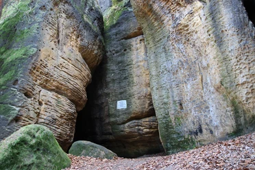
In front of the castle, continue left along the path. Follow the “red dot” hiking trail and pass a small pond. After crossing the road, you’ll soon find yourself in front of the Götzinger Cave, which is also marked with a red dot. Inside, you’ll find a dry spot for a picnic, even in drizzly weather. The cave is about 25 meters deep. On various maps, it is also listed under the name “Diebskeller.”
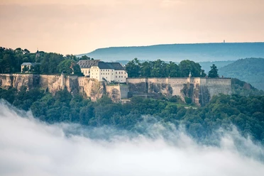
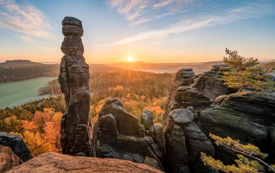
Now follow the signposts and climb the Kleiner Bärenstein. This peak is higher than the Großer Bärenstein. In 1847, a mountain inn was built up here. Around 1902, two bears were even kept here in a pen. Unfortunately, the inn fell into disrepair after the war, and today only its foundation walls remain. However, the stunning view to the southeast—featuring the majestic Lilienstein and Königstein Fortress—more than makes up for it.
The trail leads back downhill along the same path. At the fork in the trail, however, continue straight ahead and follow the “red dot” hiking trail. After about 500 m, the hike continues to the right onto the “red line” hiking trail. About 230 m further on, at the edge of the forest, turn left onto an unmarked path. This path leads past a hiking shelter and continues on to the Großer Bärenstein. Small trails lead to several lookout points. Since there are no markings, caution is advised.
It is recommended that you return the same way and turn right at the edge of the forest to rejoin the “Red Line” hiking trail. Here, the trail curves to the right in a wide arc along the base of the Großer Bärenstein. At the larger trail junction, take the right fork onto the “Hermann-Schneider-Weg” until you reach the country road. Then cross the country road and follow the path to the small pond.
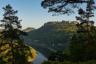
At the hiking rest area, walk straight ahead uphill along the hazelnut-lined avenue and pass an old orchard meadow with a wonderful view of Königstein Fortress. At the intersection, turn left onto the Malerweg. Here, you’ll hike to a viewpoint that had long been forgotten. It is named after the painter Johann Alexander Thiele, who created a painting here featuring a view of the Elbe River and Königstein Fortress.
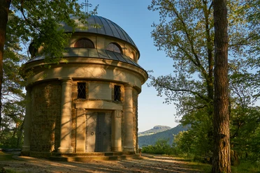
Another surprise here is an old round building that has been reconstructed and converted into the Malerweg Chapel. The so-called Biedermann Mausoleum was built as part of the castle complex. Here, the rock face drops steeply 100 meters down to the Elbe and, after a clearing in the vegetation, offers a deep view of the Elbe loop.
Walk back a short distance and head downhill to the left, passing a farm with many Galloway cattle, toward the village road “Pehnaberg.” Follow this road to the left for a short distance to the Pehnafall, the highest waterfall in Saxon Switzerland. Then walk slightly uphill and continue straight ahead at the fork in the road until you reach the bus stop at the former Thürmsdorf Inn.
Tour information
Loop Road
Summit
Equipment
- Hiking boots are recommended
Directions & Parking facilities
- Getting thereTake the B172 and follow the signs for Königstein Fortress; at the roundabout in front of Königstein Fortress, turn toward StruppenParkingFree parking: Gravel parking lot at the castle or the Thürmsdorf Mitte hiking parking lotPublic transportationArrival/Departure:
Line 241, "Gasthaus Thürmsdorf" stop
Additional information
- Thürmsdorf Castle - Activities and Events
Literature
- Buy here: Hiking Guide
Author´s Tip / Recommendation of the author
- The Rose and Rhododendron Park at Thürmsdorf Castle, which is open to the public, is a must-see. To round off the hike, a visit to the chocolate factory and café is highly recommended.
Safety guidelines
- For very athletic hikers, we recommend the ascent to the Großer Bärenstein via the so-called Riegelhofstiege. This requires sure-footedness. In wet and cold weather, the ascent via the Riegelhofstiege is not recommended. In general, the Riegelhofstiege is recommended only for the ascent.
On both table mountains, there are hardly any railings at the lookout points, and very few hiking signs. Appropriate caution is advised. Map
Nearby



Download GPX file