Pfaffendorf: To the plateau of the Pfaffenstein and around the Quirl


- 3:00 h
- 7.06 km
- 368 m
- 368 m
- 245 m
- 417 m
- 172 m
- Start: Stop Pfaffendorf Vereinshaus
- Destination: Stop Pfaffendorf Vereinshaus
Pfaffendorf Vereinshaus bus stop - Pfaffensteinweg - Nadelöhr - Barbarine - Klammweg - Oberer Kohlweg - Quirlpromenade - Diebskeller - Am Stallhübel - Querweg - Pfaffensteinweg - Pfaffendorf Vereinshaus bus stop

Good to know
Pavements
Best to visit
Directions
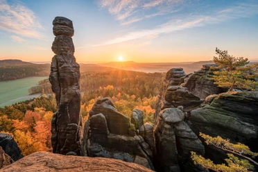
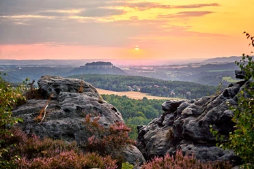
The Pfaffenstein plateau was already inhabited around 3,000 years ago. This is confirmed by Stone Age and Bronze Age finds from archaeological excavations. Between 1896 and 1912, various stone flat axes, clay vessels, a millstone and a hearth came to light in the vicinity of today's mining operations. The miner Richard Keiler found two bronze arm rings in 1921. Further excavations were carried out on the plateau in 1967, during which more pottery and a grinding stone were found. There are many mysterious places to discover on the Pfaffenstein plateau, e.g. swirl holes, caves or old ruins, and the restaurant and viewing tower are also worth a visit. Behind the mountain restaurant, a detour leads to the Barbarine, which we should not miss. According to legend, this 43 m high bizarre rock needle is a girl turned to stone: Instead of going to church, she collected blueberries on the Pfaffenstein and was cursed by her mother in anger.
After our visit to the Barbarine, we return to the mountain inn and choose the gorge path directly opposite as our descent (or take the comfortable path halfway between the Barbarine and the mountain inn). At the foot of the gorge path, we meet the Bequemer Weg and follow it, now also with the Malerweg, all the way down. On the way, we come across a plaque indicating the Bronze Age rampart: The 200-metre-long, semi-circular structure was probably intended to protect the only access to the plateau and was surrounded by a ditch. During archaeological investigations in 1959 and 1961, further pottery remains were found inside the rampart.
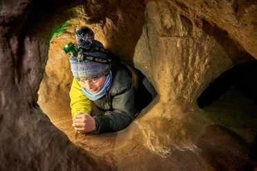
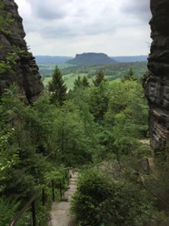
We continue along the Malerweg to the Quirl. At its foot, we turn left and discover a sandstone trough carved out of a boulder. This was intended for a farmstead, but was never collected. We leave it on the left and walk around the Quirl on the beautiful Quirl promenade, which winds its way through the forest below the rock faces. Here we can admire a variety of weathered formations such as hourglasses and caves. We find the most impressive cave at the end of our tour: a short detour takes us to the Diebskeller. This two-storey layered joint cave was first mentioned in 1692. With a length of 28 meters, a width of 8 meters and a height of up to 4 meters, it is impressively large. The stone table in the middle of the cave from 1755 is said to have been set up for a meal during the hunt for August II.
Now we return to the Malerweg trail, which we follow out of the forest until we reach the cross-path (marked with a green dot) on the right at the sports field. On this easy path, we walk along an avenue until we meet the Pfaffensteinweg again, which takes us back to the starting point of the hike.
[GPS updated 2026]
Tour information
Cultural Interesting
Loop Road
Stop at an Inn
Summit
Equipment
Hiking shoes are recommended
Directions & Parking facilities
Pfaffendorf parking lot (Pfaffensteinweg), approx. 50 spaces, subject to charge (2024: car/bicycle: up to 1 hour € 0.50; up to 2 hours: € 2.00; day ticket: € 6.00)
Additional information
Author´s Tip / Recommendation of the author
There is a viewing tower and refreshment stop on the Pfaffenstein.
Safety guidelines
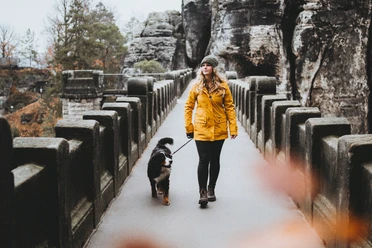
The eye of the needle and the gorge path are not suitable for dogs due to the steps and ladders. Here you can take the comfortable path.
In the Pfaffenstein nature reserve, dogs are not allowed to leave the marked paths or the existing steps and places.
Map
Hiking and cycling map
"Vordere Sächsische Schweiz" with the towns of Wehlen, spa town Rathen, Hohnstein, Königstein, Gohrisch
Scale: 1 : 15,000, GPS-capable, weatherproof - tear-resistant
Order here: www.saechsische-schweiz.de/shop
Nearby

Download GPX file