Lonely paths to the Großstein


- 2:50 h
- 9.25 km
- 185 m
- 183 m
- 174 m
- 357 m
- 183 m
- Start: Bus stop Lichtenhainer Mühle in the Kirnitzschtal
- Destination: Bus stop Lichtenhainer Mühle in the Kirnitzschtal
On this hike, you can well understand the Lusatian overthrust: At the end of the Cretaceous period, Lusatian granites were pushed over the rocks of the Elbe zone. The pressure thus exerted on the sandstone plate created the fracture system of the Elbe Sandstone Mountains. This change in the ground can be particularly well recognized by the different vegetation. The V-shaped slope form of the Knechtsbach valley and the undulations of the fields and meadows around Ottendorf indicate Lusatian granite. An impressive contrast to this is the view into the rugged rocky world from the sandstone ledge of the Großstein.

Good to know
Best to visit
Directions
We start our route at the bus stop Lichtenhainer Mühle in the Kirnitzschtal. We turn into the Knechtsbach valley, which is marked with a yellow line. At the beginning, the ascent is hardly noticeable. When reaching a fork, we follow the path to the right, marked with a green dot. After a short, steep climb, the Ottendorfer Steig leads out of the forest. Through meadows and fields, it goes to Ottendorf.
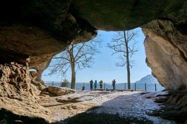
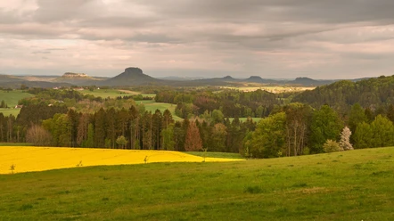
In Ottendorf, at the inn "Zum Kirnitzschtal", we turn onto Dorfstraße (Sebnitzer Straße). Then we continue through the village on Endlerstraße, following the "green line" direction Großstein. The slightly ascending path passes a memorial and the "Endlerkuppe". Upon reaching Großstein, you can enjoy beautiful views of the Kirnitzschtal and beyond: In the deeply incised Kirnitzschtal lies the Felsenmühle. Far left you can see the rock summit of Arnstein, then the Pohlshörner, and on the horizon the Jedlová (Tannenberg) in the Czech Republic and Studenec (Kaltenberg). Also visible are Kanstein, Raumberg, and Teichstein. Opposite are the Kleine and Große Lorenzstein and the Winterstein. The Große and Kleine Winterberg, far right the Affensteine with Bloßstock, and in the background the Schrammsteine are also recognizable. Close in front of us lies the Hausberg.
After enjoying the views at Großstein, you first hike back the same way and then follow the signpost (to the right) to the Felsenmühle. There is a bus stop here, and you can return from there. Those who want to hike further cross the Kirnitzsch over a stone bridge and come to the Floßersteig. Downstream – with some ups and downs – it goes until you meet the old road to Neuer Wildenstein. On this, you walk downstream to the main road. Now it's only a few meters along the road to the bus stop Lichtenhainer Mühle, the starting point of our route.
Tour information
Cultural Interesting
Loop Road
Stop at an Inn
Summit
Tour with Dog
Directions & Parking facilities
From Nationalparkbahnhof Bad Schandau by bus 241 (direction Hinterhermsdorf) to Lichtenhainer Mühle
vvo-online.de
Author´s Tip / Recommendation of the author
This hike is suitable for older children and dogs.
Nearby
")
Download GPX file