Rosenthal: Cross-border route to the Tyssaer Walls (TISKÉ STĚNY)


- 8:00 h
- 21.14 km
- 368 m
- 368 m
- 370 m
- 613 m
- 243 m
- Start: Rosenthal stop Mühlsteig
- Destination: Rosenthal stop Mühlsteig
Rosenthal stop "Mühlsteig" - Großvaterstuhl - Wormsberg - Grenzplatte - Tyssaer Walls/Tiské Stěny - Ostrov (Eiland) - Bielagrund - Dürrebielegrund - Steinbornweg - Rosenthal stop "Mühlsteig"

Good to know
Pavements
Best to visit
Directions
If the route is too long, you can already end the round trip from April to October at the Tyssaer Walls or on the return journey at the stop "Footpath to Schneeberg" and take the hiking bus back.
Furthermore, the tour is also perfect as a first stage for a two-day multi-day tour with an overnight stay in Ostrov to visit the Hohen Schneeberg on the second day. A suitable route description can be found here at this tour: From Rosenthal to the Hohen Schneeberg
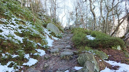
The hike starts at the "Mühlsteig" stop in Rosenthal-Bielatal and initially follows the Mühlsteig across the field to a signpost with a red stripe, which continues on the Mühlsteig and points to the Benno Cave. On the way into Bielatal, you make a short detour to the viewpoint Großvaterstuhl with an interesting view of a distinctive climbing summit and into Bielatal.
In Bielatal, you then continue to follow the red stripe in the direction of Wormsbergweg and the viewpoint (AP) Grenzplatte. On the way there, you pass the impressive Benno Cave, which you should not miss.
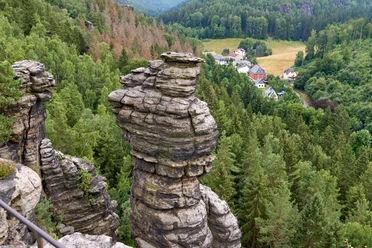
From Benno Cave, it continues on the Wormsbergweg to the Grenzplatte, a very impressive viewpoint above Ostrov, from which you can see all the way to Hohen Schneeberg and which invites you to take a break.
From the Grenzplatte, continue following the red stripe until a sharp right turn where a signpost without a marking points straight ahead to the Tyssaer Walls. This path runs directly on the border and is marked with a green stripe.
At the next larger intersection, follow the signpost and yellow stripe to the right to the "Tiské Steny" – the Tyssaer Walls.
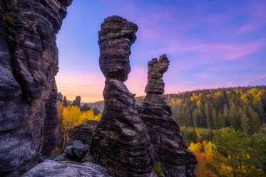
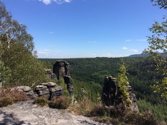
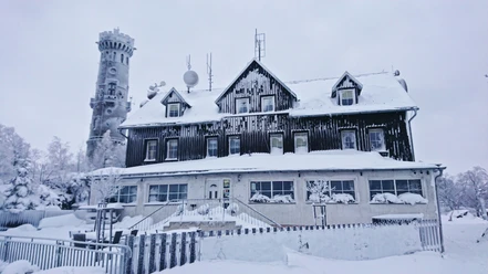
Once at the Tyssaer Walls, you embark on the circular path with the green stripe through the Tyssaer Walls until you arrive back at the rustic inn, the tourist cabin.
From the Tyssaer Walls*, walk on the red stripe and through bizarre rock formations ("Himmelreich") to Ostrov (Eiland). Then you cross Ostrov via the street to the edge of the town, where you return to a wide forest road and back into the "Bielagrund woodland area".
After one and a half kilometers, the narrow Dürrebielegrund (yellow stripe) joins from the right. Follow this always slightly ascending under steep rocks to a bridge on Steinbornweg, where a signpost with a red dot and the inscription "Circular Route Rosenthal" points back to the town.
From this point, follow the red dot to a bus stop "Footpath to Schneeberg" in the middle of the forest, and from there continue straight along the cycle path back to Rosenthal past the customs houses to the Mühlsteig.
*If the tour is too long, you can already end it with the hiking bus from April to October at the Tyssaer Walls or on the return trip at the stop "Footpath to Schneeberg" in the forest. More information and details can be found in the further description of public transport arrival.
GPS data updated 2022
Tour information
Cultural Interesting
Loop Road
Stop at an Inn
Equipment
Directions & Parking facilities
S171 via Talstraße to Königsteiner Str. to Rosenthal Mühlsteig
If you arrive by car, it is best to park at the customs houses in Rosenthal.
Arrival:
Line 242 (Königstein - Rosenthal)
Line 245 (Pirna - Leupoldishain - Rosenthal)
Line 247 (Rosenthal - Oelsen - Bad Gottleuba - Berggießhübel)
Departure (shortcut for the return trip):
Line 217 ((Pirna -) Border Crossing Bahratal - Petrovice - Tisa - Sneznik - Rosenthal
Line 219 (Pirna - Cotta - Berggießhübel - Bad Gottleuba - Border Crossing Bahratal)
Additional information
Current information can be found here: https://www.ceskesvycarsko.cz/de/sehenswertes/sehenswurdigkeiten/tyssaer-waende
Literature
Order now: Hiking Guides
Author´s Tip / Recommendation of the author
Furthermore, trekking poles are very helpful along the route, and it is advisable to carry sufficient provisions - especially drinks - since there is only one refreshment stop after about 10 kilometers at the Tyssaer Walls, the tourist hut Tisá (opening hours: http://www.turistickachatatisa.cz/), or after about 15 kilometers in Ostrov (Eiland).
Map
Buy here: Hiking Maps
Nearby

Download GPX file