From Rosenthal over the Grenzplatte to the Hoher Schneeberg


- 7:00 h
- 20.85 km
- 507 m
- 507 m
- 369 m
- 723 m
- 354 m
- Start: Rosenthal stop Mühlsteig
- Destination: Rosenthal stop Mühlsteig
With an elevation gain of around 500 meters and only moderate, albeit sometimes long, climbs, the route is not particularly difficult in terms of profile, but is still classified as moderately difficult due to its length of around 20 kilometers.
In addition to the route, there is also a small geological highlight - the so-called Benno Cave - in the Bieltal valley or after the short ascent out of it, which is why you should definitely have a torch or even a headlamp with you.
Otherwise, there are a few places to stop along the route in Ostrov and in Schneeberg (Sneznik) or on the Hoher Schneeberg, where you can enjoy good Bohemian food and fortify yourself accordingly.
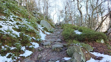
All in all, it is a very worthwhile hike, which definitely makes a better impression in spring, summer and fall than in winter!

Good to know
Best to visit
Directions
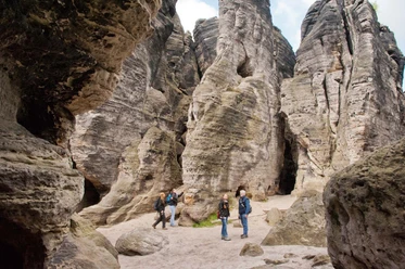
The hike begins in Rosenthal at the "Mühlsteig" stop and from there follows the yellow dot markings and then a little later the dash into the Bielatal valley. You will pass a small but beautiful view, the so-called Großvaterstuhl, which you should not miss.
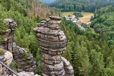
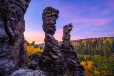
From the Bielatal, follow the red line along the Wormsbergweg to the view on the Grenzplatte and make a short detour to the Bennohöhle cave at the beginning.
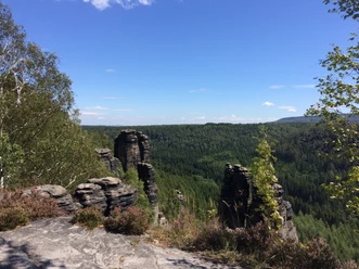
From the Grenzplatte, continue along the red line towards Tyssaer Wände, leaving the path at a right-hand bend to continue straight ahead on a border path towards Tyssaer Wände.
The border trail is marked with a green line and ends at a signpost in Bohemian Switzerland (Czech Republic), which points left towards Ostrov with a yellow marker. You can now follow this marking to Ostrov (Eiland) and from there to the High Snow Mountain (Děčínský Sneznik). Or you can continue straight ahead before Ostrov at a junction to the left and then pass the small but nice campsite instead of the large Hotel Ostrov.
From the campsite, follow the yellow line first to the right up the road in Ostrov and then in a bend to the left into the forest and further out of the valley. From there, it is recommended to follow the red line up to the High Schneeberg, as this marking is clearer and more frequent.
Once you arrive in Sněžník, you first hike up to Schneeberg via a road before the path branches off to the right and you are back in the countryside below Hoher Schneeberg. From there, follow the red line up the Hoher Schneeberg, from where you already have a breathtaking view from the eastern viewpoint.
Continue along the high ridge of the Hoher Schneeberg to the lookout tower and the chalet before following the green markings back along the road to Sněžník - down the mountain.
Back in Schneeberg, you can now get on the hiking bus (more information in the further description) and end the tour or hike right through the village back towards Rosenthal.
If you want to hike back (or have to from November to March because there is no bus back), first follow the road and the blue line through the village until it leads back into the forest in a slight right-hand bend just outside the village. From there, you first take a wide border path and then cross back over the border into Saxon Switzerland into Germany, where you first follow the red dot and then a little later, at the "Fußweg zum Schneeberg" stop, the cycle path to Rosenthal.
You will pass the customs houses, where you can also park if you are traveling by car, and from there you can easily find your way back to the starting point of the tour - the "Mühlsteig" stop.
Tour information
Loop Road
Stop at an Inn
Directions & Parking facilities
Regarding the possible shortcut for the way back, you can take the hiking bus line 217 from Schneeberg (Sneznik) back to Königstein or Pirna from April to October.
For timetable information: https: //www.vvo-mobil.de
Literature
The route description contains links to further information on the most important and interesting places.
Author´s Tip / Recommendation of the author
We recommend taking binoculars for the views and a light for the Benno Cave. Otherwise, of course, sturdy shoes and hiking clothing suitable for the weather are recommended, as well as a rucksack with food.
You should also allow enough time to enjoy the area and the views, which is not a problem in spring, summer and fall. In winter, it looks a little different according to the pictures, but this can also have its charm.
Safety guidelines
For winter tours in the area, the following items are useful or necessary:
- GPS device for navigation
- Dry change of clothes (socks)
- Waterproof and above all sturdy shoes
- Sufficient food (warm drinks)
- Functioning cell phone for emergency calls
- Emergency blankets with insulation
- Snowshoes
Some of the refreshment stops are closed from November to March, but especially in winter, or are only open at weekends. Particular attention must be paid to possible snow breakage in the treetops during or after heavy snowfall, as there is a danger to life from falling trees or branches!
Nearby

Download GPX file