From Rosenthal through the Bielatal area to the Schweizer Mühle


- 4:20 h
- 15.34 km
- 393 m
- 393 m
- 352 m
- 529 m
- 177 m
- Start: Rosenthal
- Destination: Schweizermühle
Mühlsteig stop | Rosenthal or Schweizermühle car park - customs houses - "yellow stripe" at hiking border crossing - Dürrebielegrund - Nymphenbad - Bielagrundweg - small and large border stone - Grenzplatte - path "yellow stripe" - path "red stripe" - Wormsbergweg - Ottomühle - towards Schweizermühle - path "yellow dot" - detour: Bielablick (Felsengasse) - Schweizermühle

Good to know
Pavements
Best to visit
Directions
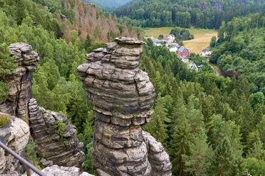
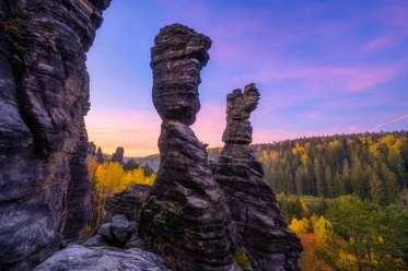
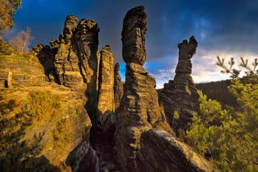
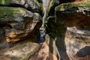
The route starts at the Mühlsteig stop in Rosenthal or already at the Schweizermühle car park. Via the customs houses, you reach the Fußweg zum Schneeberg stop (in summer you can also take buses directly here). You follow the trail marker "yellow stripe" past the hiking border crossing on the right to the upper beginning of the Dürrebielegrund. Passing climbing peaks such as the Dürrebielenadel or Falkenwand, you walk down to the right to the Nymphenbad. After the Nymphenbad, you continue left towards the Grenzplatte, climbing the slightly ascending Bielagrundweg. After 700 m, turn right and pass the small and large border stone. Now the ascent to the Grenzplatte begins. When you reach the next intersection, leave the path marked with the "yellow stripe" and keep right. You now follow the path marked with the "red stripe" down over the Wormsbergweg to the Ottomühle. On the road towards Schweizermühle, turn right behind the car park into the path marked with a "yellow dot". You then have the option to make a detour up the stairs to Bielablick to the Felsengasse. Then continue over Bielablick with many breathtaking views into the valley towards Schweizermühle.
Tour information
Cultural Interesting
Loop Road
Stop at an Inn
Equipment
Sturdy footwear required
Directions & Parking facilities
Motorway A17 to Pirna or from Dresden on the B 172 via Heidenau or right bank Elbe via Pillnitz, past Pirna, towards Königstein, after Krietzschwitz turn right onto the S169 after 500 m towards Rosenthal-Bielatal.
Schweizermühle car park
Additional information
Tourist information Rosenthal-Bielatal: +49 (0) 35033 70291
Literature
Order now: Hiking guide
Safety guidelines
Accessible year-round, not in ice and snow glaze
Map
Nearby


Download GPX file