From Bad Schandau to Hoher Schneeberg


- 9:00 h
- 27.25 km
- 1,026 m
- 564 m
- 120 m
- 723 m
- 603 m
- Start: National Park Station Bad Schandau
- Destination: Sněžník
The route is a point-to-point hike and is moderately difficult in profile – mostly along forest and woodland paths but also offers some challenging ascents via stairs and a few sections on trails. Due to the overall length, however, we classify the route as difficult, and it can be completed as a demanding day hike in one day.
If the route is too long for you in one day, you can stay overnight after about 15 kilometers in the Rotsteinhütte (a trekking hut) and find more information in the details.

Good to know
Best to visit
Directions
The tour starts at the National Park Station in Bad Schandau, which you can conveniently reach by Dresden S-Bahn. From here, you first follow the road (B169) eastward for a short distance, from which you have a nice view of Bad Schandau.
After about 800 meters, turn sharply right onto Täppichtsteig heading up towards Kleinhennersdorf (red line), where you will first meet the Forststeig – a left-Elbe trekking route. You then follow this trekking route marked with a yellow line, partly painted on trees, up and over Kleinhennersdorfer Stein.
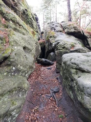
On Kleinhennersdorfer Stein, a detour to the namesake viewpoint with a wonderful view of the right-Elbe part of Saxon Switzerland is recommended. Additionally, there are three very interesting and impressive caves on Kleinhennersdorfer Stein – the Lichterhöhle, Hampelhöhle, and Eishöhle, the latter of which you may have to search for partly between rocks.
After Kleinhennersdorfer Stein, the route continues to Papststein, guided by a red dot, from which you can see not only the tour's destination – the Hoher Schneeberg – but also the entire left-Elbe Saxon Switzerland.
Next, the route leads to Cunnersdorf, for which you must follow the road briefly towards Cunnersdorf after descending from Papststein before turning left onto a forest path followed by a field path following the yellow line. At the next signpost, turn right and follow the red line downhill via Kirchsteig to Cunnersdorf.
In Cunnersdorf, you can admire directly on the roadside the neo-Gothic neo-Romanesque church of Cunnersdorf as well as some beautiful half-timbered houses before continuing a short distance through the village to Katzstein – yellow line.
Back in the forest, leave the yellow-line path and turn left – then follow the green dot over Katzstein to Rotstein.
At Katzstein, do not miss the viewpoints "Signal," Katzsteinfels, and Schneebergblick, from where you can gain breathtaking impressions.
Rotstein itself is a small climbing peak with an interesting stone structure and a slightly reddish color. After Rotstein, continue along the Forststeig to the Rotsteinhütte – a trekking hut where you can stay overnight for a fee.
After Rotsteinhütte, follow the Forststeig downhill and then a short stretch to the right along Mittelhangweg before leaving it sharply left via Nässeweg and following it down into the valley to Cunnersdorfer Bach. Once in the valley, turn right and follow the forest road and the signs to Fuchsteich along Fuchsbachweg. Along the way, you pass the old raft bridge and several very interesting rock formations before reaching the protected Fuchsteich.
Behind Fuchsteich, follow a path crossing the German-Czech border and then continue on some forest tracks until you meet a paved road that reconnects to the Forststeig. Follow this and the green line up to Hoher Schneeberg, from which you have a spectacular view.
The tower on Hoher Schneeberg is generally closed, but the key can be purchased for just 1 euro at the kiosk behind it.
For descending to Sněžník (Schneeberg), it is recommended to follow the yellow and green lines over Hoher Schneeberg and then the red line down to Sněžník. Upon arrival in Sněžník, you can take the hiking bus directly from the hotel and inn "Hřebenová bouda" (ridge hut) on the main road back to Königstein or even Pirna.
Directions & Parking facilities
For arrival, taking the S-Bahn from Dresden to Bad Schandau is recommended, especially since you can use the hiking bus from Sněžník (Schneeberg) for the return journey and get back to Königstein or Pirna.
You can find the current timetable for S-Bahn Dresden here: https://www.vvo-online.de/de/fahrplan/fahrplanauskunft/index.cshtml
The current timetable for the hiking bus is here: www.vvo-online.de/de/fahrplan/fahrplanbuch/linien?line=242
Additional information
The route description contains further information linked to the main places on and along the route.
An overnight stay in the trekking hut requires a fee, and tickets must be purchased before starting the tour – all details can be found here: https://forststeig.sachsen.de
Author´s Tip / Recommendation of the author
For the route, it is definitely recommended to carry enough food and drink, as there are no dining options along the way except for the hut on Papststein at the beginning, an inn in Cunnersdorf, and the hut on Hoher Schneeberg. Sturdy footwear is clearly an advantage, and hiking poles make progress easier.
Those who also want to take a closer look at the caves on Kleinhennersdorfer Stein should bring a flashlight or even a headlamp.
It is also recommended to always have binoculars with you to better experience and enjoy the beautiful views!
Safety guidelines
Some viewpoints are unsecured and require sure-footedness. Otherwise, the route itself is relatively safe and fairly easy.
Nearby


