Rathewalde: Hohburkersdorfer Rundblick with Himmelschlüsselweg


- 1:30 h
- 4.62 km
- 148 m
- 148 m
- 290 m
- 392 m
- 102 m
- Start: Rathewalde village center parking lot
- Destination: Rathewalde village center parking lot
Rathewalde - Hohburkersdorfer Rundblick - Zeschnig - Himmelschlüsselweg - Viebigweg - Rathewalde

Good to know
Pavements
Best to visit
Directions
From the parking lot, walk through the village to the intersection with Hohnsteiner Straße. The street then leads uphill through the upper part of Rathewalde directly to the Hohburkersdorfer Rundblick marked with a blue line.
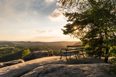
The Hohburkersdorfer Rundblick apparently had strategic significance in 1813 – as commemorated by the Napoleon Linden tree. In 1923, a monument was erected in honor of the soldiers from the First World War. Today, it is a wonderful picnic spot for hikers with a panoramic view that is second to none. The impressive view stretches from the Eastern Ore Mountains, the Bohemian Central Mountains, the Zittau Mountains, northwards towards Stolpen, and as far as Bischofswerda.
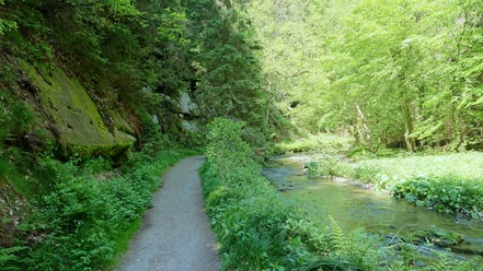
The path continues to Hohburkersdorf. Cross the street and continue to the right. Hohburkersdorf is a former forest strip village. The small street ends at Brückenstraße. Here turn right and follow it through the village until the signpost for Himmelschlüsselwiese branches off to the right. (Alternatively, you can continue on the E3 trail, which turns into a forest path at the end of the street and here follows the Himmelschlüsselweg signposting.)
You are now in Zeschnig, a small village laid out as a circular village. Especially in spring, the many blooming Himmelschlüssel flowers are a natural spectacle here. The Himmelschlüsselwiese is strewn with March bells or the aforementioned Himmelschlüssel flowers in spring. Once back up, turn right at the bee hotel.
Passing breeding ponds for trout, carp, and others, as well as over a meadow (unmarked), the route now leads again to the main road called Rennstrecke. The name comes from the hillclimb races that took place here from 1926 to 1933. By 1939, the Rennstrecke had been expanded into the 10 km long “Großdeutschlandring” and was intended to be a counterpart to the Nürburgring. But the outbreak of war and the post-war period prevented any significant racing activity. The last official race was held in 1951.
After the bus stop, a wonderful panoramic path called Viebigweg descends to the right and leads straight back to Rathewalde. Here you cross the main road and meet the Malerweg trail, which leads back to the parking lot.
Perhaps the village church, a pub, or the outdoor pool is open to relax the afternoon.
GPS data updated 2022
Tour information
Cultural Interesting
Loop Road
Stop at an Inn
Tour with Dog
Equipment
Hiking boots, provisions
Directions & Parking facilities
From the A highway exit Pirna towards Bastei and at the gas station before the Bastei exit, go straight ahead to the next village: Rathewalde. Turn right to the parking lot.
Parking lot at the outdoor pool or in the village center
Literature
Order here: hiking guides
Author´s Tip / Recommendation of the author
In summer, swimming clothes belong in the backpack, because after the beautiful comfortable hiking route, you can relax the afternoon in the Rathewalde adventure pool. The route is also well suited for smaller groups.
Picnic possibility at the Hohburkersdorfer Rundblick or dining at the Gasthaus zur Rennstrecke.
Map
Buy here: hiking maps
Nearby


Download GPX file