Großer Zschirnstein


- 5:30 h
- 17.73 km
- 571 m
- 569 m
- 125 m
- 545 m
- 420 m
- Start: Krippen parking lot
- Destination: Krippen parking lot
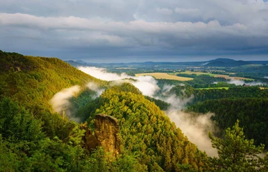
The highest elevation in Saxon Switzerland is the Großer Zschirnstein, a slightly tilted table mountain with an excellent panoramic view. At its southern end is the "Mittagsstein," which at 562 m is the highest point of the massif. Here you can enjoy an impressive view.

Good to know
Pavements
Best to visit
Directions
The hike starts at the Krippen parking lot. After the church, walk a bit along Kleinhennersdorfer Straße and then continue on the Koppels bergweg ("Red Dot"). After a detour to Kohlbornstein, your path leads to Rölligmühle and then to Kleingießhübel.
From here, take the Hirschgrundweg to the Großer Zschirnstein, which you will hike uphill. The return route leads along Salzleckenweg and over Wolfsberg to Reinhardtsdorf. Tip: Visit the worth-seeing village church. On the Püschelweg ("Green Dot") leading into the Elbe valley, you return to Krippen.
Tour information
Loop Road
Stop at an Inn
Directions & Parking facilities
From Dresden, the best way to reach Krippen is via Pirna - Königstein - Bad Schandau.
New paid parking lot for about 8 cars and about 12 parking spaces at the transformer hut, which fill up quickly. Therefore, we recommend using public transport for arrival.
Arrival/Departure:
- S-Bahn S1 (Meißen - Schöna) to Krippen station
- Bus line 252 (Schöna - Bad Schandau - Schmilka), stop: Krippen Zum Kohlbornstein
- Ferry, hiking ship
Safety guidelines
Please note: in the Saxon Switzerland National Park, only marked trails may be used in the core zone! Fines can be imposed for violations.
Nearby


Download GPX file