Wheelchair route "Once around the Lilienstein table mountain"


- 1:10 h
- 4.38 km
- 47 m
- 47 m
- 222 m
- 269 m
- 47 m
- Start: Lilienstein car park (see map, start of route)
- Destination: Lilienstein car park (see map, end of route)
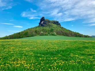
The hike leads with no major elevation changes around one of the most striking table mountains of Saxon Switzerland. Unfortunately, the Lilienstein is not accessible for wheelchair users, as the summit can only be reached by stairs. Nevertheless, there is much of interest to discover for visitors with mobility impairments even below the mountain: from the Sellnitz youth education center of the national park administration over the small, romantically located hamlet of Ebenheit to the impressive poplar avenue known as Napoleon or Kaiserstraße.

Good to know
Pavements
Best to visit
Directions
From the car park on Liliensteinstraße, it first goes a short distance back until the partly paved access road to the Sellnitz education center branches off to the east. We follow this until the Sellnitz houses come into view. Turning sharply right, the path first climbs over a meadow, then gently in the forest to a junction where we turn left. Shortly after, the difficult access path to the northern ascent of the Lilienstein branches off uphill to the right, but we continue gently downhill straight ahead. With slight ups and downs but on well-drivable forest ground, we now roll the Kirchsteig towards Ebenheit. Especially during the leafless season, the Elbe and houses of Königstein in the valley can be spotted downhill through gaps in the trees. When the forest path meets the somewhat gravelly access road to the freight elevator to the Lilienstein, after a short and steeper rise we soon reach the first houses of Ebenheit. From here we use the small access road to the village for the return route. Looking south, there is a view over the (not visible) Elbe valley to Königstein Fortress, soon followed by the impressive rock formation of the Lilienstein. Along the poplar-lined Kaiserstraße (called Napoleonstraße by the locals), it initially rises gently and then returns to the starting point of our route.
Note: Instead of the access road to the Sellnitz youth education center, the somewhat further uphill parallel hiking trail through the forest can also be used for the first almost quarter of the route, which leads into the path described above at the junction before the turnoff to the northern ascent.
Tour information
Loop Road
Suitable for Pushchair
Directions & Parking facilities
By car
- from Dresden / Pirna on the right bank of the Elbe via Lohmen to Waltersdorf, then turn right after the junction to the spa town of Rathen
- from Bad Schandau via Porschdorf to Waltersdorf, then turn left in the middle of town
Large hiking car park at Lilienstein (parking meter)
Additional information
At both the Sellnitz education center and Ebenheit, a festival with regional relevance is regularly held once each in late summer and autumn. More information can be found under the keywords "Sellnitzfest" and "Bergwiesenfest."
Author´s Tip / Recommendation of the author
Both Napoleonstraße and the small village of Ebenheit are also directly accessible to everyone because the route there is completely paved.
Safety guidelines
The route should not be done alone in a wheelchair, but only with companions without mobility impairments, as even for sporty wheelchair hikers occasional pushing assistance is advisable. Moreover, during prolonged wet conditions, part of the hike is not recommended due to the then softened hiking trails.
Nearby


Download GPX file