Handbike route "Through the Schwarzbachtal"


- 1:05 h
- 9.10 km
- 94 m
- 201 m
- 131 m
- 265 m
- 134 m
- Start: Lohsdorf parking lot
- Destination: Polenztal hiking parking lot in Porschdorf
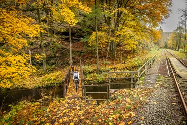
A hiking trail leads from Lohsdorf to Goßdorf-Kohlmühle through the romantic Schwarzbachtal. Since this path uses some sections of the old track bed of the former narrow-gauge railway line to Hohnstein, but the track is not asphalted, a robust or off-road capable handbike is recommended. Riding through two short railway tunnels as well as over the viaduct that crosses the Sebnitzbach is one of the undisputed highlights of the route. Attention: The short, steep ascent (about 100 m) on a gravel path just behind the rest area at the former Buttermilchmühle requires additional pushing support from companions! Also, for crossing the arched metal grate bridge over the Sebnitz about 700 m later, help may be necessary! Under these conditions, however, the short adventure route becomes an impressive experience.

Good to know
Pavements
Best to visit
Directions
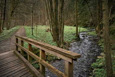
From Lohsdorf, we first continue on the road towards Sebnitz. Before it climbs to Ulbersdorf, we turn right into the Schwarzbachtal. On initially quite decent ground, we now roll lightly downhill following the yellow stripe marking. After about 1.7 km, we reach the first tunnel of the former narrow-gauge railway. It is recommended to shorten the hiking trail and ride through the tunnel under the rock spur. However, the gravel of the old track bed is clearly noticeable here. The next 1,100 meters must also be hoped to be managed on a very bumpy track without a flat tire until shortly before the next tunnel, where the path becomes better again. The route turns left now; however, before that, the detour straight ahead through the second tunnel and the immediately following viaduct is definitely recommended. Afterwards, however, we must return to the hiking trail because the narrow path down from the embankment on the other side of the Sebnitzbach cannot be ridden with the handbike as a shortcut.
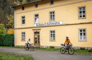
Our route now follows the hiking trail in a bend around the hill, on which, under favorable conditions, even the ruins of the Goßdorf robber castle can be spotted. After passing under the railway line to Sebnitz and crossing the first bridge over the Sebnitzbach, we next reach the rest area at the former Buttermilchmühle. Even under favorable conditions, one can only see the foundations of it. Then it goes about 150 m up a short and very difficult-to-manage steep section due to the gravel. Most handbikers will need pushing support here because the drive wheel spins on the poor ground. Where a path branches off to the left at the crest, we continue straight ahead and nearly as steep downhill. Shortly after, we pass the viaduct over which we previously rode after the second tunnel. After another ride under the (still operational) railway line Bad Schandau - Sebnitz, we reach a railway keeper's house and shortly after the arched metal grate bridge, over which we cross the Sebnitzbach a second time. Because of the strong curve of the arch, additional help may be necessary here again – apart from the fact that handbikes with low ground clearance probably bottom out here. After this second critical spot, we only need to struggle for 500 m on a narrow meadow path parallel to the railway line until the trail conditions improve again. It then continues on a slightly gravelly road to the village Kohlmühle. After crossing the tracks again, we turn right at the next intersection, pass the stop Goßdorf-Kohlmühle, and about 200 m further at the next junction take the narrow left street. This leads us further downhill, always along the railway line, passing under it several times, later past the stop Porschdorf, to the mouth of the Polenztal. The route ends at the hiking parking lot in Porschdorf, but it can also be continued on public roads to Bad Schandau or back to the starting point (see further info above).
Tour information
Cultural Interesting
Directions & Parking facilities
From Pirna, drive over the Sachsenbrücke and take the first exit onto S167 to the left. At the bending priority road, veer diagonally left/straight ahead onto the S164 and drive up the hill. After about 1.1 km, turn left onto Lohmener Straße towards Lohmen. After Lohmen, continue on S165 towards Bastei. Follow signs to Rathewalde. At the intersection at Hockstein in Rathewalde, go down the old race track and back up to Hohnstein. At the bending priority road, turn left towards Ehrenberg and Lohsdorf. About 400 m after entering Lohsdorf, the parking lot is on the right side.
Parking lot in Lohsdorf near the Schwarzbachtalbahn railway line or parking lot about 500 m after leaving Lohsdorf towards Sebnitz at the mouth of the Schwarzbachtal (free of charge)
Additional information
Highly mobile handbikers can also extend the proposed route here into a loop. In this case, steep inclines of up to 12% must be overcome on the frequently used public road through Tiefen Grund from Porschdorf towards Hohnstein, before turning right onto the significantly quieter road to Goßdorf, and a little later turning left onto the road to Lohsdorf. In total, an additional almost 7 km and 200 vertical meters must be managed.
Author´s Tip / Recommendation of the author
There is this information about the history of this narrow-gauge railway line.
Safety guidelines
Attention: If the route is traveled in the described direction, it is also well passable with a towing handbike. However, it is all the more important to observe the riding instructions (see tour description) – help from companions without mobility impairments is absolutely necessary at two short passages!
Nearby