Handbike tour "Between Rathen and Bad Schandau"


- 2:10 h
- 26.91 km
- 207 m
- 207 m
- 113 m
- 243 m
- 130 m
- Start: Health resort Rathen
- Destination: Health resort Rathen
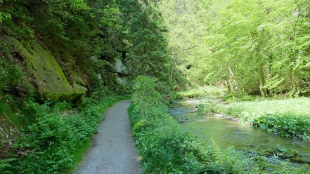
Most of this tour, which is rich in views, leads along the Elbe cycle path on both sides of the river between the spa town of Rathen and Bad Schandau without any major differences in altitude.However, as there is no continuous traffic route on the northern bank of the Elbe between the Königstein district of Halbestadt and the spa town of Rathen, there is also a larger, briefly steep ascent from the Elbe valley to the plateau below the impressive Lilienstein table mountain. It may also be worth making a short detour here to the houses of Ebenheit with the extensive panorama between Königstein Fortress and Lilienstein (see also this tour). The only sections of the tour that involve heavy traffic are the approach and crossing of the Elbe bridge in Bad Schandau and shortly afterwards the 800 m or so on Hohnsteiner Straße to the junction to Prossen.

Good to know
Pavements
Best to visit
Directions
Here we have to cross the Elbe on the prestressed concrete bridge of the main road, whereby the footpath is also open to cyclists and has a lowered ascent and descent on both sides. At the end of the bridge, the route continues to the right, following the signpost to Hohnstein. However, we leave this main road after just 800 m and turn left, following the signs to Prossen. You should also follow this signposting carefully, because at the end of the Bad Schandau district, the onward route is somewhat hidden immediately to the right of the traffic circle in front of the castle and now leads to Halbestadt. After that, there are no more turn-offs to follow.
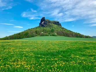
After approx. 4.5 km, when most of the houses in the Königstein district of Halbestadt and the ferry landing stage are behind us, we leave the road, which soon ends as a dead end. The signposts at this turn-off clearly indicate the only possible route for cyclists (see picture in the gallery). For the first 100 m, the forest path runs on asphalt, as the gradient peaks briefly at 14% just before the first hairpin bend. After the flat section to the second hairpin bend, the gradient is again around 10% until it levels out at around 8% for the next 1.2 km. This part of the slope is not asphalted, but only has a fine gravel surface. At the end of the strenuous ascent, the impressive rock formations of the Lilienstein greet you, and shortly afterwards the forest path returns to asphalt.
If you want to experience more beautiful views of the Lilienstein and Königstein Fortress, we recommend the short detour to the houses of Ebenheit, which is also approx. 2.5 km long for the outward and return journey on the same route. In this case, you have to turn right onto the poplar-lined Kaiserstraße and then return along the same road. Otherwise we keep to the left.
The narrow road then leads us gently up and down to Waltersdorf, finally climbing slightly through the village. At the top of the crossroads, you can already see the road signpost to Rathen, where we turn left. Shortly after the rocky massif of the Gamrig, the descent into the Elbe valley becomes very steep and winding with a gradient of 18%, which is why particular caution is required here due to the possibility of traffic. However, there are once again beautiful views of Rathen and its rocky landscape.
Keeping straight on through the spa town, we finally reach the ferry, which takes us back to the starting point of the tour on the other side of the Elbe (the ferrymen have a mobile ramp ready for access to the ferry if required).
Tour information
Loop Road
Stop at an Inn
Suitable for Pushchair
Directions & Parking facilities
S-Bahn S1 to stop Kurort Rathen, Königstein or Bad Schandau
Additional information
Author´s Tip / Recommendation of the author
Safety guidelines
The 18% steep descent to Kurort Rathen should be ridden with caution, as oncoming vehicles are always to be expected on the narrow, winding road.
Nearby


Download GPX file