Gottleuba valley panorama path


- 6:30 h
- 22.00 km
- 620 m
- 620 m
- 289 m
- 505 m
- 216 m
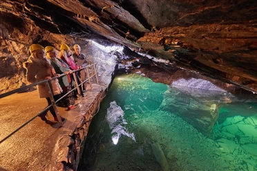
- Start: 01816 spa town Berggießhübel, Talstraße 2, car park at the visitor mine
- Destination: 01816 spa town Berggießhübel, Talstraße 2, car park at the visitor mine
The start and end of the hike is the car park opposite the tourist information and the visitor mine in Berggießhübel. However, the route can also be joined at any other point along the hiking trail.
The spa town has a long tradition and originated as a result of intensive iron ore mining. The hike first takes you over the Ladenberg, the Zehistaer walls and the rock bridges to the Jagdstein. From there you get a beautiful view into the Bahre valley and towards the Eastern Ore Mountains and it invites you to take your first rest here. Afterwards you hike to the lime kiln in the Gottleuba district of Giesenstein and can enjoy the view over the Gottleuba valley on the forest bench. The further route leads a short way uphill over the cobbled street to the junction to the spa clinic. Halfway up you reach the MEDIAN Clinic Bad Gottleuba. The first of the 30 buildings on the approx. 28-hectare site were already built in 1910 and it is still the largest coherent Art Nouveau complex in Germany. Here are also the medical history collections, which display among other things medical instruments and apparatus from the past century.
The path then leads you above the clinic buildings over the Helleberg to the rock area Raabsteine. On both sides of the approx. 400-metre-long hiking trail rise rugged sandstone rocks with peculiar weathering formations. Afterwards you reach the district of Hartmannsbach via a hollow way and along extensive pasture areas, and further on the viewpoint of the dam inaugurated in 1974. After a rest in the shelter you walk a short way back and leave the paved path. Here you follow the marking of the Gottleuba valley panorama path again. You pass through a dark coniferous forest and reach, keeping steeply downhill left, the large slope meadow above the district of Haselberg. Continuing left along the forest edge you soon reach the former fish mill on the road to Hartmannsbach. You keep right here, cross the bridge over the Gottleuba and climb the steps up to the Tannenbusch.
After a longer climb the ridge path is already in sight. From up here you have a magnificent view into the Gottleuba valley. You stay on the ridge until you reach the iron stairs about 600 metres later and enter the town again. Continue to follow the symbol of the Gottleuba valley panorama path and hike over the Fourteen Holy Helpers path up to the Augustusberg (food stop available in the panorama restaurant). Enjoy the beautiful view of the Gottleuba dam and the expanse of the Eastern Ore Mountains.
After a refreshment the path leads you further over the Laubbusch path to the Dürrenberg to the car park "panoramic view Gottleuba valley". From here it is not far to the panoramic height with the Bismarck tower. This can be climbed; the key for the tower can be obtained at the house located on the site. The next "high point" awaits you at the Erich Mörbitz view, where another forest bench invites you to pause. From there you reach the starting point in Berggießhübel again after a short time.

Good to know
Pavements
Best to visit
Directions
Berggießhübel, car park at the visitor mine - Ladenberg - Zehistaer walls - rock bridges (viewpoint) - Jagdstein (viewpoint) - lime kiln (viewpoint & forest bench) - Thomas Müntzer path - cross path to the spa clinic (viewpoint) - hiking trail above the Bad Gottleuba spa clinic - rock area Raabsteine (shelter) - Hartmannsbach - viewpoint dam (viewpoint & shelter) - ridge path Tannenbusch (viewpoint) - Röhrensteig - Bad Gottleuba church - Fourteen Holy Helpers path - Kurvenstraße (viewpoint) - Augustusberg (viewpoint & shelter) - Laubbusch path - Dürrenberg - panoramic view Gottleuba valley (viewpoint & shelter) - panoramic height/Bismarck tower (viewpoint & shelter) - Erich Mörbitz view (viewpoint & forest bench) - Kirchberg - Sebastian Kneipp street - Berggießhübel, car park at the visitor mine
viewpoint = viewpoint
Places to eat along the hike:
- Gasthof "Grüner Wald" in Berggießhübel
- Gasthof Hillig in Bad Gottleuba
- Confectionery and café Schönbach in Bad Gottleuba
- Mountain hotel Augustusberg in Bad Gottleuba
- Restaurant "Am Goethepark" in Bad Gottleuba
- Snack bar at the Rätze butcher’s in Bad Gottleuba
- Inn "Bruno Haensel" in Berggießhübel
- Café Müller in Berggießhübel
- Snack bar at the Rätze butcher’s in Berggießhübel
- Hotel & restaurant "Sächsisches Haus" in Berggießhübel
Tour information
Cultural Interesting
Loop Road
Stop at an Inn
Summit
Tour with Dog
Equipment
Directions & Parking facilities
Additional information
Author´s Tip / Recommendation of the author
Map
Nearby

Download GPX file