Hiking on the Montan-historical hiking trail


- 6:26 h
- 23.30 km
- 512 m
- 512 m
- 291 m
- 643 m
- 352 m
- Start: Berggießhübel
- Destination: Berggießhübel
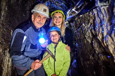
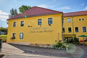
Visitor mine Marie-Louise-Stolln - "Saxon House" - Flood monument - former Hänselmühle - Schloss Giesenstein - Hammergut Haselberg - burial mound on Kulmer Steig - road to Oelsen and Breitenau - new Oelsen cemetery - Oelsen church - Hohler Stein - (Detour right up the slope toward panoramic height - Bismarck Tower) - Berggießhübel - St. Petri Church Berggießhübel - starting point

Good to know
Best to visit
Directions
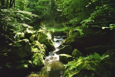
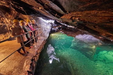
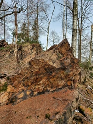
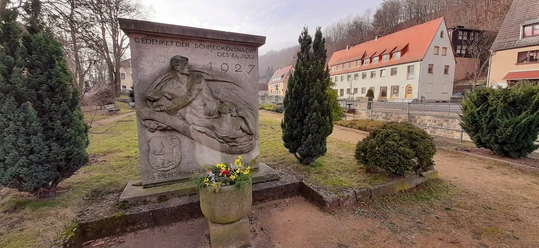
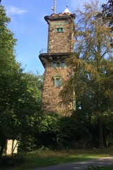
The hiking trail begins at the Marie-Louise-Stolln visitor mine next to the Gottleuba river. We follow the footpath to the road bridge over the Gottleuba to the former train station and the ore cart as a memorial to the last shift in the Berggießhübel mining. The path runs along the Gottleuba, past the "Saxon House" to the "Johann-Georgen Bath." On the left, behind the former railway track to Bad Gottleuba, lies a small spa park called the "Fritzegarten." On the right opposite is the beautiful castle of the former Friedrichsthal estate. The trail continues along Kneippstraße, past the flood monument commemorating the 1927 flood disaster, to Kirchberg. During the disaster, on the night of July 8 to 9, an entire row of houses next to the Gottleuba was washed away by a 4-meter-high wave, and 88 inhabitants drowned. We continue hiking over Kirchberg, along the Poets' Path to the former Hänselmühle. Then the path branches off left from the Poets' Path towards Giesenstein onto the plateau. We walk left along the forest or slope edge until we cross the path to the panoramic height, called the Witch Steps. During the mining period, a workers' path of the Gottleuba miners came down here from the Mother of God camp and continued to Giesenstein – the mining path. The path continues along the forest edge down to Giesenstein. On the left beside the path in the forest, you can admire the deep caves caused by the drivers transporting large amounts of ore from the ore deposit to the smelters and forges. The mining path also served in the past for transporting iron ore (Iron Road). The hiking trail passes Schloss Giesenstein toward Bad Gottleuba to the combined foot and cycle path. We follow this path to the ascent to the settlement path, continue over Finkenweg, the Goethepark to Badstraße and further to the market. A detour to the nearby church is also worthwhile. Now we cross the market, walk past a historic post distance column and the parish community house, and finally reach Talstraße to Hartmannsbach. Past the old Bähr mill to the junction to Hartmannsbach, we also see the fishermen's mill. We follow Talstraße along the Gottleuba to Hammergut Haselberg. The trail follows the road to Oelsen to the junction with the old construction road ("At the dam"). It crosses this and follows the "Old Oelsen Way" toward Oelsen, which is also a section of the old Kulmer Steig (Kulmer Steig is a synonym for traffic routes from the Elbe valley over the eastern Ore Mountains into Bohemian Kulm. It is an old road system of partly ruined and unpaved historic traffic routes). The hike passes an old Bronze Age burial mound on the Kulmer Steig. Our path continues along the "Old Oelsen Road" to the road to Oelsen and Breitenau. Here we must walk a bit along the road. Our planned route leads from the young cattle enclosure again on a hiking trail in the direction of the new Oelsen cemetery. From there, you reach the beautiful village church along the driveway to Oelsen. Now we still have to walk along Oelsen Road, still on the route of the prehistoric Kulmer Steig, pass an old stone cross, and finally arrive at Oelsen Height. Here is a good opportunity to have a nice picnic and enjoy the "high-altitude air" and the view a little longer. When we are ready for the return, we first walk back toward Oelsen. At the Oelsen church, the path leads us left toward the road. We only cross it and continue walking toward the Gottleuba reservoir until we reach Hohler Stein. Now the hiking trail continues along the reservoir toward Bad Gottleuba. After some time, we meet the junction between Talstraße and the "Old Oelsen Road," or the Kulmer Steig, again. This time we follow the "Old Oelsen Road" north and reach Hellendorfer Straße, which continues to Bad Gottleuba. Our path passes through Bad Gottleuba (again via the market), continues on Pirnaer Straße, and finally turns right onto Bahnhofstraße until it meets Siedlungsstraße, which we already walked on the outward journey. If you have no more stamina, you now walk similarly to the way out and save unnecessary altitude meters. However, for those who still want to enjoy a beautiful view, a few meters further right go up the slope toward the panoramic height and can enjoy a wonderful panoramic view of Saxon Switzerland from the Bismarck Tower. After this crowning conclusion to this strenuous route, it is about one kilometer back to Berggießhübel, where we reach our starting point again via Kirchberg and Pfarrweg (past St. Petri Church Berggießhübel).
GPS data updated 2022
Tour information
Cultural Interesting
Loop Road
Equipment
sturdy footwear required
Directions & Parking facilities
Additional information
Tourist info Bad Gottleuba-Berggießhübel: 035023 52980
Literature
Order here: Hiking guide
Safety guidelines
good fitness
Map
Buy here: Hiking maps
Nearby

Download GPX file