On the E3 through Saxon Switzerland - Stage 1: From Geising to Augustusberg


- 5:40 h
- 21.22 km
- 388 m
- 499 m
- 389 m
- 664 m
- 275 m
- Start: Geising station
- Destination: Augustus Hill
Geising - Lauenstein - Liebenau - Gottleuba dam - Bad Gottleuba-Berggießhübel - Augustusberg

Good to know
Pavements
Best to visit
Directions
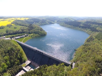
After the bridge, we come across the Gottleuba, whose direction of flow we follow leisurely downhill into the Oelsengrund. We hike along the Gottleuba until we reach the dam of the Gottleuba reservoir. Passing the right bank of the dam, we reach the entrance to the spa town of Bad Gottleuba via the Alter Oelsener Weg, but the E3 does not lead directly through the spa town, but only touches the town and immediately turns right again, uphill to the Augustusberg. From the vantage point, there is a beautiful open view of the Gottleuba dam and the ridges of the Eastern Ore Mountains. The stage ends here with overnight accommodation in a mountain hotel.
Tour information
Cultural Interesting
Equipment
Directions & Parking facilities
We do not recommend traveling by car, as it is very inconvenient to get back to Geising from Bad Gottleuba-Berggießhübel.
On a weekday, it takes about 2.5 hours by public transport from Augustusberg to Geising (2-3 changes).
Parking lot Alte Straße in Geising
Arrival:
Wanderexpress RB 72 to Geising
Departure:
Bad Gottleuba OT Augustusberg bus stop
Bus routes 219 and 247
More information and timetable information at https://www.vvo-mobil.de/
Additional information
Thanks to good public transport connections in the area and a well-branched network of marked hiking trails, the route can be varied or shortened in many places.
Author´s Tip / Recommendation of the author
Nearby


