Bohemian Switzerland peak route: Marienfels - Wilhelminenwand - Rudolfstein - Schaunstein


- 6:30 h
- 16.63 km
- 642 m
- 622 m
- 209 m
- 481 m
- 272 m
- Start: Vysoká Lipa
- Destination: Vysoká Lipa
Vysoká Lípa - Grundmühle (Dolnský mlýn) - Jetrichovice - Marienfels (Mariina skála) - Wilhelminenwand (Vilémínina stěna) - Rudolfstein (Rudolfův kámen) - Schauenstein (Šauštejn) - Vysoká Lípa

Good to know
Pavements
Best to visit
Directions
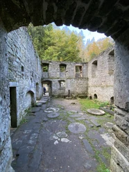
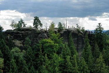
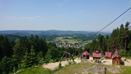
The route starts at the hiking car park in Vysoká Lipa. First, it goes downhill into the Ferdinandsklamm to the ruins of the mystically appearing Grundmühle. The Grundmühle, also called Dolský Mlýn, was originally a mill, specifically a sawmill. Later, the mill was repurposed for grinding grain and brewing beer. At the end of the 19th century, the boat trip on the Ferdinandsklamm ended here. During this time, a refreshment stall was also built. After 1945, the mill was abandoned. The route continues along the Kirnitzsch. Those who have the desire and time can also make a detour to the ..-viewpoint. Here, you can look down into the Kirnitzschklamm. Then, it continues along the cool valley of the Kirnitzsch until the village of Jetrichovice is reached. Here, there is an opportunity to stop for refreshments. After strengthening, the route continues (red trail) to the first peak: the Marienfels. Since ..., a beautiful viewing platform has stood here. The view stretches over the outskirts of Saxon Switzerland far into the Czech landscape. Shortly afterwards, you reach the second viewpoint of the peak tour: the viewpoint at the Wilhelminenwand, which was originally called the "Black Wall", but today is named after Princess Wilhelmine Kinsky, the wife of Rudolf Kinsky. From here, you can see the Marienfels and also the Rudolfstein. By the way: the ridge trail runs along here - an approximately 100 km long stage hiking trail modeled after the Malerweg. The E3 is also part of the peak tour. You continue following the red trail until you finally reach the Rudolfstein, formerly called "Hoher Stein". Since 1824, it has borne the name of Prince Rudolf Kinsky, who visited the rock at that time and later had a shelter built there. From the highest rock, you have a unique panoramic view over the landscape of the back Bohemian Switzerland. A path leads to the summit, and towards the end, there is a challenging ascent over stone steps. Afterward, the path leads fairly straight without major elevation changes. At the intersection, shortly before the destination in Vysoká Lipa, the red trail leads about 500 m to the last viewpoint - the Schaunstein. A castle ruin, in which a few rooms carved into the rock have been preserved. Then, the path leads back to the intersection towards the starting point Vysoká Lipa (yellow trail).
Tour information
Cultural Interesting
Loop Road
Stop at an Inn
Summit
Equipment
Sturdy hiking boots are mandatory for this hike.
Directions & Parking facilities
By car from Bad Schandau via Schmilka, cross the border to Hrensko and then turn left towards Prebischtor. From here, continue to Vysoka Lipa on the S25861.
Small car park at Hotel Lipa (approx. 15 cars)
Arrival and departure:
Bus lines 434 and 436
Connections see timetable booklet for download
Additional information
Leisure hikers should also plan extra time at the viewpoints, as 20 minutes can go by quickly here.
Author´s Tip / Recommendation of the author
Bring sufficient food and drinks. Refreshment options are available in Jetrichovice and Vysoká Lipa.
Safety guidelines
Challenging hike, good condition and fitness required.
Nearby

Download GPX file