Cunnersdorf: Spitzstein, Lampertstein, Katzstein, and Signal


- 4:15 h
- 14.22 km
- 489 m
- 489 m
- 244 m
- 463 m
- 219 m
- Start: Cunnersdorf Schmiede Bus Stop
- Destination: Cunnersdorf Schmiede Bus Stop
Cunnersdorf – Spitzer Stein (Spitzstein) – Neuteich – Lampertstein – Neuteich – Pechloch – Katzstein – Signal – Cunnersdorf

Good to know
Pavements
- Street (3%)Asphalt (8%)Gravel (16%)Trail (36%)Path (37%)
Best to visit
- suitableDepends on weather
Directions
- Most of the towns in Saxon Switzerland were settled in the 12th century. Settlers from Lower Saxony, Thuringia, and Franconia made their way there and also founded the town of Cunnersdorf. It’s safe to assume that the founder’s name was Konrad. From this, the place names “Kunradsdorf” (1379) and “Connersdorffe” (1539) evolved into Cunnersdorf.
From the bus stop on Cunnersdorfer Straße, we turn onto Alte Rosenthaler Straße and follow the yellow line markings toward Bielatal/Spitzstein. (Don’t be confused: The rock is referred to as both “Spitzstein” and “Spitzer Stein.”) Once we’ve left the houses of Cunnersdorf behind, the road turns into a dirt path and later into a forest trail. For the final few meters up to the Spitzen Stein, we climb steep steps before finally reaching the 410-meter-high rock via an iron ladder.
The Spitzen Stein was first made accessible via simple wooden ladders in 1885. It wasn’t until about 100 years later that the iron climbing structure and railing were built. From here, you have a wonderful panoramic view of the table mountains of Saxon Switzerland.
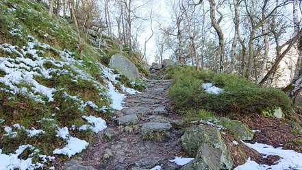
After this detour, we continue hiking along the yellow-stripe trail marker to the Spitzstein Bivouac and onto the Wurzelweg. Now you have to be careful not to miss the turnoff onto a small path to the right about 400 meters past the Spitzstein Bivouac! At the turnoff, you’ll find a post marked with the forest trail symbol (a yellow vertical line). We follow the forest trail to the Neuteich and then continue toward Lampertstein. The trail winds its way along beneath the rock faces until we reach the steps leading up to the Lampertstein and turn right toward the lookout point.
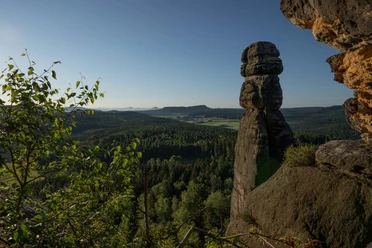
According to an old legend, the Lampertstein is named after its former owner. From here, you can see the Königstein, Lilienstein, Pfaffenstein, Gohrisch, Papststein, Falkenstein, the Schrammsteine, and all the way to the Großer Winterberg.
For the return trip, we take the Kammweg trail, stop to enjoy the“Schneeberger Blick” viewpoint, and leave the Forststeig after about 200 m. A small path turns sharply to the left, and we follow the yellow-striped trail marker toward Katzstein. Once back on the “Promenade,” we head back the same way toward Neuteich. From Neuteich, we hike uphill to the right on the Pechweg (a paved forest road) until we cross the wide Wurzelweg (yellow line). There is a covered rest area there. We continue straight ahead on the “Pechlochweg” hiking trail. The higher we climb, the narrower and steeper this path becomes. The signpost reads “Connection (green dot) to Katzstein and Signal.” Once we reach the Mäusebornweg (green dot), we turn left; then the Forststeig trail markers reappear, and we hike, following the Forststeig signs, turning right at the next intersection and continuing on to the Katzstein (iron ladder to the lookout) and the Signal.
It is believed that this area was once the habitat of numerous wildcats. The last one was killed in this region, not far from the border, in 1809. A steep ladder (only for those with a head for heights) leads up to the narrow rock (474 m) of the Katzstein. On a clear day, you can see the distant mountains of Unger and Tanzplan; a little closer are the Kohlbornstein, the Laasensteine, the Schrammsteine, the Winterberg, the Zirkelstein, and the Kaiserkrone; and very close by are the Kleiner and Großer Zschirnstein.
The Signal is the lookout point on the north side of the Katzstein massif. This spot served an important function, as it was an observation post for the Royal Forestry Administration to monitor for potential forest fires.
After descending from the Signal, we come across the green dot trail marker again at a seating area. We follow the Spitzsteinweg to the right until we reach the intersection with Winterleitenstraße. From here, we hike left along Winterleitenstraße (marked with a red line) back to Cunnersdorf and our starting point.
Tour information
Loop Road
Summit
Tour with Dog
Equipment
Hiking shoes and provisions
Directions & Parking facilities
- Parking
Very few parking spaces (about 8) across from the Cunnersdorf Church (free of charge): To reach the starting point of the hike, walk to the intersection of Cunnersdorfer Straße and turn left there. After a few meters, you’ll reach the trail signs.
Additional information
- The tour is located in the Saxon Switzerland Landscape Conservation Area. For more information about the landscape conservation area and the rules that apply there, please visit the website of the National Park and Forestry Administration.
Information about the Cunnersdorf Forest Pool (A visit to the forest pool can be easily combined with the tour; however, the pool will be closed during the 2026 season due to construction work and is therefore not included in the tour description.)
Author´s Tip / Recommendation of the author
- The tour can easily be shortened to about 9 km by skipping the Lampertstein and turning off directly at Neuteich toward Katzstein and Signal.
Safety guidelines
- The tour is suitable for older children who enjoy walking. Due to the many stairs—some of which are steep (often with metal mesh steps)—it is not recommended for dogs unless they can be carried.
Nearby




Download GPX file