Up to the Lilienstein


- 3:00 h
- 7.86 km
- 393 m
- 393 m
- 123 m
- 409 m
- 286 m
- Start: Prossen Castle
- Destination: Prossen Castle
Route: Prossen Castle - Gründelweg - Sellnitzgrundweg - Kirchweg - Lilienstein north descent - Lilienstein - south ascent - Kirchweg - Ringweg - Prossen Castle

Good to know
Pavements
Asphalt (9%)
Gravel (7%)
Trail (22%)
Path (62%)
Best to visit
suitable
Depends on weather
Directions
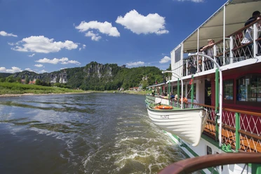
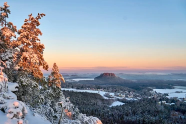
The highlight of the circular hike is probably the most striking table mountain in Saxon Switzerland: the Lilienstein. We leave Prossen from the castle and head north through Gründel, initially ignoring the signs to Lilienstein. After the last houses, we cross the small bridge over the Gründelbach stream and keep to the right immediately afterwards. The path through the shallow ground leads us to the plain, where the majestic stone now greets us on the left. We walk directly towards the mountain on blue markings, pass the Franzosenborn, a covered spring, and finally climb up the northern ascent, with the path also leading over a steel ladder. The jagged, 415-metre-high summit offers several viewpoints in all directions - for example of the Schrammstein range and the Winterberg to the east. We can also make out our starting point, Prossen Castle, on the Elbe, which flows 300 meters below us. Königstein Fortress can be seen to the southwest. The impression is not deceptive: the fortress hill opposite is 360 meters above sea level. N. N. is considerably lower than the table mountain on which we are standing. Until mid-December and from the end of March, the rustic Felsbaude restaurant up here is open for refreshments. We should definitely not miss the westernmost point of the summit plateau, even if the path there requires surefootedness and a head for heights. However, the panorama here is spectacular. We choose the southern descent for our way back. The path, still marked in blue, takes us down many steps into the forest. There we keep to the left towards Ebenheit, while the path to the parking lot continues to the right. The path now leads us along the edge of the forest with a view of the Königstein and takes us past the valley station of the freight elevator back to the western side of the Lilienstein, from where we started the ascent. Here we follow the yellow markings in the direction of Prossen and pass the former Sellnitz sheep farm, which is now used as a national park training center. The last section of the trail is steeper again, but uncomplicated along the Elbe slope. We reach Prossen at the old garden estate, which is already within sight of the castle.
Tour information
Loop Road
Stop at an Inn
Equipment
- Onion-skin clothing and winter hiking boots
- Backpack with hiking map, snacks, thermos flask with a warm drink, smartphone, flashlight, first aid kit
- Hiking poles, ice goggles
Directions & Parking facilities
Getting there
.
Parking
Parking lot: Prossen Castle
Public transportation
from/to Bad Schandau: S-Bahn S1 to Bad Schandau National Park station, bus 253 to Prossen Wendeplatz
Timetable information: www.vvo-online.de
Additional information
.
Literature
.
Author´s Tip / Recommendation of the author
From Thursday to Saturday from 2 p.m. to 6 p.m., the historic garden hall invites you to a cozy end to your winter hiking day with the Café Kerzenschein. Over coffee, cake and delicious mulled wine, you can also find out how the 17th century castle woke up from its slumber four years ago.
Safety guidelines
This hike is a black route (difficult tour, with steep ascents, steps and on paths, not always passable, especially in snow and icy conditions). Steep ascent and descent to the Lilienstein, surefootedness and a head for heights required!
Map
Nearby


Download GPX file