Handbike tour "Along the Hohe Straße"


- 3:40 h
- 37.18 km
- 397 m
- 397 m
- 119 m
- 421 m
- 302 m
- Start: National Park Station Bad Schandau
- Destination: National Park Station Bad Schandau
This scenic handbike route leads both through narrow rocky valleys and over panoramic heights in the Hintere Sächsische Schweiz. Depending on stamina, mood, and equipment, several route variants are possible. The perfectly paved sections of the tour mostly run on public motor roads, which are sometimes quite heavily used by tourists. In contrast, the "Alte Hohe Straße," mostly only a dirt road, has no car traffic. Further explanations about possible alternative routes and the condition of the surface can be found in the route description.

Good to know
Pavements
Best to visit
Directions
From the market square in Bad Schandau, we initially follow the signs towards Hinterhermsdorf and after about 300m turn into the Kirnitzschtal. The road through the Kirnitzschtal is quite busy, especially on weekends, but is easy to ride due to its barely noticeable incline and very good surface. Up to the Lichtenhainer Waterfall, we are accompanied by the tracks of the historic Kirnitzschtalbahn. After the Lichtenhainer Mill, the road's incline gradually increases. We pass the Felsen-, Neumann-, and Buschmühle and soon reach the point where the road leaves the Kirnitzschtal and climbs towards the Saupsdorfer Räumicht.
Immediately after the Räumicht Mill, we leave the main road to the left and now ride up the small valley to Saupsdorf. Always staying on the main road, we finally turn left again and leave the village towards Sebnitz. After an initial descent, it goes uphill again until we finally reach the highest point just before the descent into the Sebnitz district of Hertigswalde. Here the "Hohe Straße" branches off to the left, and we continue on it. This section here turns out to be a dirt road with a rather rustic condition in places.
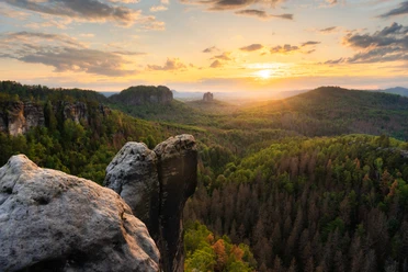
After reaching a forested height, an impressive view towards the Hintere Sächsische Schweiz opens up for the first time. The route continues rather gravelly with a descent to the connecting road between Ottendorf and Sebnitz. We roll about 300m to the right before the "Alte Hohe Straße" branches off again as a dirt road to the left. Although the short steep uphill (max. 10%) is paved, several paved speed bumps additionally make the ascent more difficult. Assistance from helpers may be required here. The panorama compensates us richly for the effort. Once it levels out again, the asphalt ends, and we continue on a dirt forest road through the forest called "das Keilholz." After longer rain, the following mostly flat section may be very muddy and therefore impassable.
Finally, it goes downhill towards Lichtenhain. As with the previous climb, the now following steep descent (approx. 12 - 14%) is paved and equipped with several paved speed bumps. (If the tour is ridden in the opposite direction, this steep ramp is the executioner.) At the forest edge, we pass the lovely shelter "Zum alten Sportplatz." Here, the most physically demanding part of the tour lies behind us, but we must soon endure motor traffic again on the popular panoramic road between Sebnitz and Bad Schandau. For this, only blacktop will glide under the tires.
Always along the main road, it sometimes goes slightly uphill, but mostly downhill past the village of Lichtenhain and later through Mittelndorf and Altendorf. Here too, unforgettable views open up over a large part of the Sächsische Schweiz. On a nice day, an unforgettable experience. After a rushing descent, we reach Bad Schandau again and orient ourselves from the church back to the market square.
Those who want to avoid the gravel track of the "(Alten) Hohen Straße" or shorten the tour are recommended the direct connection from Kirnitzschtal to Lichtenhain. Coming from Bad Schandau in the Kirnitzschtal, about 200m before the Lichtenhainer Waterfall, a small paved driveway branches off to the left after the village of Lichtenhain, which is closed to public motor traffic. Although the valley and later the village have quite steep uphill sections (consistently 8-10%, steep sections up to max. 14%), the surface is consistently good. In Lichtenhain, you then rejoin the original route.
Already on the way back, just before the start of the long (but heavily used) descent to Bad Schandau, the tour can be extended by another 6 km by turning right shortly after the exit of the village of Altendorf onto a side road and following the signs to "Kohlmühle." At the next intersection at the end of the first descent, keep right towards the village "Kohlmühle" in the Sebnitz valley. We finally follow this on a small road only open to local traffic, downstream, i.e., westward, until we meet the main traffic connection between Hohnstein and Bad Schandau at the entrance to Porschdorf. On the now heavily traveled road, it then goes back to the starting point.
Tour information
Loop Road
Directions & Parking facilities
P+R National Park Station Bad Schandau
Additional information
This route can be combined with other route suggestions, for example with the wheelchair routes "From the Kirnitzschtal to the Wild Meadow", "Through the Affensteine", and "To the Kuhstall Cave on the New Wildenstein" (only arrival), since the paths used there are also approved as "Bike route in the National Park".
Author´s Tip / Recommendation of the author
Several nice picnic spots on or near the car-free "Alte Hohe Straße" invite you to have a picnic. Anyone who wants to take a closer look at the rock formations in the distance should definitely consider bringing binoculars.
Safety guidelines
Since the majority of the route runs directly on public roads without accompanying bike paths, appropriate caution is required when riding. For low tour handbikes, a flag and a daytime rear light are also recommended for better visibility. Due to the temporarily relatively high motor vehicle traffic (including motorcycles), it is recommended to do the tour on a weekday outside of peak commuting hours.
Attention: The section on the "Alte Hohe Straße" between the Ottendorf-Sebnitz road and the junction onto the public road above Lichtenhain is not passable with handbikes with low ground clearance (race bikes)! There, several paved speed bumps (intended to prevent cars passing) at the beginning/end prevent easy crossing, as the frame touches the ground.
When using a hooked-up or adaptive handbike, pushing assistance by a companion might be required on some steep climbs. However, it is ensured that in the worst case (no progress), by returning on the access route, better rideable terrain can also be reached alone.
Nearby


Download GPX file