The Saxon variant of the E3 - from Geising to Bad Schandau


- 27:35 h
- 90.47 km
- 2,613 m
- 3,073 m
- 114 m
- 663 m
- 549 m
- Start: Geising in the Osterzgebirge
- Destination: Bad Schandau - Schmilka district
The route through Saxon Switzerland joins the route coming from the Eastern Ore Mountains in Bad Gottleuba. Via the Gottleuba dam, the Bielatal valley, Königstein Fortress, the Lilienstein, Hohnstein with the Brandaussicht, the Schrammsteine and the Großer Winterberg, this section leads to the border with the Czech Republic in the Bad Schandau district of Schmilka. Along the way, you cross practically all facets of the Elbe Sandstone Mountains: From the stone ridge landscape of the Osterzgebirge to the sandstone rock areas along the tributaries of the Elbe, you explore the left Elbe table mountain areas and finally immerse yourself in the highly rugged rocky areas characterized by cool valleys and steep ascents in the right Elbe Saxon Switzerland National Park. The final highlight is the basaltic Großer Winterberg.
The section from Geising to Bad Gottleuba, which still runs through the Eastern Ore Mountains, is included in this tour.

Good to know
Pavements
Best to visit
Directions
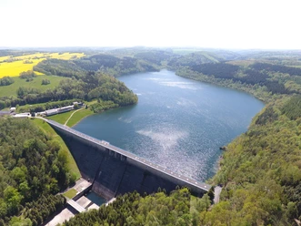
After the bridge, we come across the Gottleuba, whose direction of flow we follow leisurely downhill into the Oelsengrund. We hike along the Gottleuba until we reach the dam of the Gottleuba reservoir. Passing the right bank of the dam, we reach the entrance to the spa town of Bad Gottleuba via the Alter Oelsener Weg.
However, the E3 does not lead directly through the spa town, but only touches the town and immediately turns right again, uphill to the Augustusberg. From the vantage point, you have a beautiful open view of the Gottleuba dam and the ridges of the Eastern Ore Mountains. You can spend the night in the mountain hotel of the same name.
From Augustusberg, the trail descends through woods and meadows to Markersbach. We keep left and walk along the Bahra stream to the junction with Rosenthaler Straße. There we turn right, but are only on this road for a short time, as we leave it again directly at the next crossroads and turn right again (dead end "Buchenhain"). We cross the district of Buchenhain and reach a forest path again. In the forest, we turn right onto the Schwert-A-Weg. This leads us in the direction of Rosenthal, first over the Hirschstange past the moor pond (nice resting place). Immediately after the moor pond, we turn left onto the Mehlsteig and then right at a T-junction onto a narrow forest path that takes us down to the Theilemannweg. We follow this to the left into the district of Ottomühle. In the village, we follow the hiking signs in the direction of Schweizermühle, which leads us through the exciting rocky area around the Hercules Columns. There are several detours here to enjoy beautiful views of the popular climbing area.
Once we reach the Schweizermühle district, we turn left after the parking lot and head towards the room and labyrinth, partly via stairs. Shortly after the ascent, we pass a neighbor, which also offers an interesting view. At the next major crossroads, you can take a detour to the Sachsenstein (green dot), where a steep, narrow ladder takes you to lofty heights with another great view. Otherwise, we turn right at the crossroads, following the signs to Raum and Labyrinth. We pass the Kamphütte and soon reach the road to Raum. We follow this road, pass the town sign after a short while and take the road opposite at the crossroads, which turns off to the right. The signpost in the middle of the crossroads shows us the way to the labyrinth. We take the left-hand bend in the road, but leave it soon afterwards and follow the path branching off to the right. At the next crossroads, we keep right and soon reach the Panoramahöhe. If you turn off here with the green dot to Bielatal, you will find overnight accommodation there again.
We continue from Panoramahöhe to the labyrinth, briefly crossing the road again before entering the forest once more. The panoramic view from the Bernhardstein opens up on the right. The descent now leads us to the rock labyrinth, which we can explore on a detour. At the crossroads before the labyrinth, the E3 leads us to the right onto the Hirschstange, which we follow to the road between Königstein and Leupoldishain. On the way, there are unobstructed views of the Pfaffenstein, Lilienstein and Königstein Fortress. On the other side of the road, the Harald Schurz Trail branches off; we follow this and the Donkey Trail to Königstein Fortress. You should allow at least two hours for a visit to the fortress. The descent from the fortress leads partly via steps into the town center of Königstein. Here you can stay overnight again.
We continue by ferry to the right bank of the Elbe. There we first turn right, then immediately left again and continue uphill past the "Luxusboofe" to the Königstein district of Ebenheit. Turning right, a short section of the trail takes us leisurely through meadows until the southern ascent up the Lilienstein challenges us again. We are now in the Saxon Switzerland National Park. On the plateau, a rock restaurant takes care of the hiker's physical well-being. We descend via the northern descent, which takes us back to the foot of the Lilienstein via short sections of ladder. We follow the church path and later keep left onto the Lottersteig trail, which we follow to the Elbe and then on to the spa town of Rathen.
In the spa town of Rathen, we follow the signposts to the Bastei. Opposite the Hotel Amselgrundschlösschen, the hiking trail leads uphill to the world-famous Bastei Bridge and the surrounding viewpoints. The Bastei viewpoint offers a wonderful view of the Elbe valley. It is possible to stay overnight at the Berghotel Bastei.
We leave the Bastei area and follow the Bastei road to the parking lot. Here we turn right and keep right at the next major crossroads. Following the Gansweg, we reach the Schwedenlöcher gorge and enter the core zone of the national park. Before descending, we recommend a short detour to the pavilion viewpoint, which shows us the Bastei bridge from a completely different perspective.
Over 600 well-built steps lead us downhill through the Schwedenlöcher. Once we reach Amselgrund, we turn left and follow the path uphill past Amselfall to Rathewalde. We cross the village straight ahead and finally reach Hohburkersdorf, stopping at the Hohburkersdorfer Rundblick, before turning right in the village towards Zeschnig. The path meets the Hohburkersdorf stream and makes a sharp bend to the right before taking us to Zeschnig. We cross the village again straight ahead, shortly afterwards come to the road and follow it keeping to the left. We pass the Hockstein tavern and reach the Hockstein parking lot at the next bend in the road, where we can leave the road again. The hiking trail now takes us to the Hockstein with a beautiful view of the Polenztal valley.
Through the Wolfsschlucht gorge, we reach the Polenztal valley via well-built steps, where we turn right, follow the Polenztalweg for a short distance, cross the bridge on the right behind the Zum Polenztal inn and ascend through the picturesque Schindergraben to Hohnstein. It is possible to spend the night in Hohnstein.
From the town center of the castle town, follow the signs to Brand. After approx. 45 minutes, we reach the Brand viewpoint, also known as the balcony of Saxon Switzerland, via the well-developed Brandstraße. In the Brand-Baude we can fortify ourselves for the kilometers ahead, there is also a national park information point here.
We climb downhill over the Brand steps, about 800 of them, into the Tiefen Grund and reach the road between Hohnstein and Bad Schandau. We walk along the stream on a narrow path parallel to the road until we reach the entrance to the village of Porschdorf. There we turn left and walk along the Sebnitz river and the railroad tracks to the Kohlmühle stop on the National Park Railway. We follow the narrow Sebnitz valley road uphill, cross a larger road and are now on the path towards Bad Schandau. Above the village we come to a parking lot, on the other side of which we take the Schillerpromenade downhill. This brings us to the Kirnitzschtalstraße.
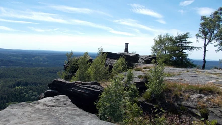
For overnight stays in Schandau, we turn right here and reach the center of Bad Schandau. However, the E3 turns left and crosses the Kirnitzsch at the Ostrauer Brücke bridge. We climb up to the Bad Schandau district of Ostrau, which is unique due to its old villas. We cross the village, keeping to the left of the road on the footpath until we turn right into Klüftelweg at the large parking lot. This leads us into the Zahnsgrund (a little way up the road is the Schrammsteinbaude, where we can stop for refreshments). We cross the road and enter the cool, idyllic Lattengrund opposite. At the top, this meets the Obrigensteig trail, which we follow to the left. After the national park information board, we reach the entrance to the Schrammsteine - the Schrammtor. From now on, we hike through rocks below the Schrammstein range. The Jägersteig trail leads us up to the ridge. If you want to take in the Schrammstein view, turn left at the top. From here, there is a fantastic panoramic view of the rocky world of Saxon Switzerland.
Return the same way back to the upper end of the Jägersteig and continue along the Schrammstein ridge path, which is a little rough in places. After a while, we come to the Breite-Kluft viewpoint, which offers a magnificent view. We hike back along the Reitsteig trail, which soon brings us to the path to the wilderness: Two boardwalks have been laid out here, depicting and bringing to life the forest development after the forest fire and after storms.
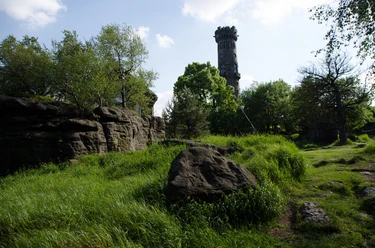
At the next crossroads, we keep to the right, pass the Wurzelweg and are on the final ascent, as we have soon reached the Großer Winterberg. There is a small snack bar here in the high season. The descent into the Elbe valley leads along the attractive mountain path (if you wish, you can also take a detour to the Kipphorn viewpoint). After the first part of the mountain path, we come to the Winterbergstraße. As there is greater danger in the lower part of the mountain path due to unstable dead wood, we turn left here and follow the detour via Winterbergstraße until Erlsgrund turns off to the right. This leads us further downhill and finally we reach the Bad Schandau district of Schmilka, where the E3 long-distance hiking trail ends on German territory. There are various places to stop for refreshments in Schmilka, and it is also possible to stay overnight here. There is a connection to the S-Bahn station in Schöna via the ferry.
Equipment
Directions & Parking facilities
- Take the Deutsche Bahn to Dresden main station or Dresden-Neustadt station. Continue with the S-Bahn (S1) in the direction of Pirna/Bad Schandau.
- At the Heidenau stop, change to the Müglitztalbahn and travel in the direction of Altenberg to the Geising stop.
Departure
- take the ferry from Schmilka to Schöna, where there is a stop on the S1
- Alternatively, take the bus from Schmilka to Bad Schandau to the national park railway station, where you can connect to local and long-distance services
- and numerous bus routes
Additional information
Thanks to good public transport connections in the area and a well-branched network of marked hiking trails, the route can be varied or shortened in many places.
Author´s Tip / Recommendation of the author
Lauenstein: falconer's fountain on the market square, Renaissance castle with museum
Bad Gottleuba: dam, Augustusberg viewpoint
Rosenthal-Bielatal: Pillars of Hercules (bizarre rock needles), Langenhennersdorf rock labyrinth (detour)
Königstein: Königstein Fortress, Lilienstein
Kurort Rathen: idyllic town center, Rathen rock stage, Bastei bridge, Schwedenlöcher
Hohnstein: Hohnstein Castle, Brandaussicht
Bad Schandau: Schrammsteine with Schrammtor and view (detour), Weg zur Wildnis, Winterberg
Safety guidelines
Path markings in the national park
Even outside the national park, you will be hiking through a protected area for large parts of the route: the Saxon Switzerland landscape conservation area. You can find out more about the protected areas on the national park website, for example about the rules that apply there.
Nearby


