Cunnersdorf: To the Pfaffenstein


- 4:00 h
- 11.00 km
- 484 m
- 495 m
- 243 m
- 417 m
- 174 m
- Start: Cunnersdorf
- Destination: Cunnersdorf
Cunnersdorf - Kirchsteig - Todweg - Pfaffenstein Promenade (red dot) - Steinerne Scheune - Pfaffensteinweg - Nadelöhr - Goldschmidthöhle - Barbarine - Bequemer Weg - Forststeig - Niederer Kohlweg - Königsteiner Steig (green line) - Cunnersdorf

Good to know
Best to visit
- suitableDepends on weather
Directions
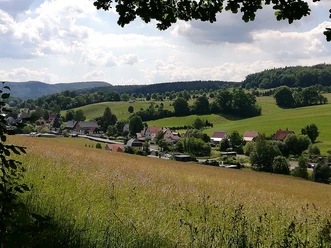
- The hike begins in Cunnersdorf and initially follows the Kirchsteig and Todweg trails for a short distance. It then continues along the Pfaffenstein Promenade (red dot) past the Steinerne Scheune, a fascinating rock formation at the foot of the Pfaffenstein. Next, follow the Pfaffensteinweg to reach the Pfaffenstein via the famous Nadelöhr. Once there, it’s worth taking a detour to the Goldschmidthöhle and, of course, to the Barbarine. To return to Cunnersdorf, leave the Pfaffenstein and descend via the Bequemen Weg, past the Jäkelfels, and follow the Malerweg for a short distance until you turn left onto the Forststeig (yellow brushstroke) and finally onto the Niederer Kohlweg. Then continue a short distance along the Königsteiner Steig (green line) until you reach your destination, the small village of Cunnersdorf.
Tour information
Cultural Interesting
Loop Road
Summit
Equipment
- Sure footing and sturdy shoes are required.
Directions & Parking facilities
- Getting thereVia Königstein, take the B172 toward Gohrisch or Pfaffenstein to Cunnersdorf, or coming from Bad Schandau via Krippen, Kleinhennersdorf, and PapstdorfParkingNo public parking available nearby; parking is available at the Waldbad Cunnersdorf, approximately 1.6 km from the start/finish line.
Literature
- Order Now: Hiking Guide
Author´s Tip / Recommendation of the author
- We recommend stopping for a bite to eat at the Pfaffenstein mountain restaurant.
Safety guidelines
- We recommend using the "Eye of the Needle" only when climbing.
Map
- Buy here: Hiking maps
Nearby







Download GPX file