Wheelchair tour "Thürmsdorf views"


- 1:05 h
- 4.12 km
- 50 m
- 50 m
- 204 m
- 251 m
- 47 m
- Start: Thürmsdorf Castle
- Destination: Thürmsdorf Castle

Good to know
Pavements
Best to visit
Directions
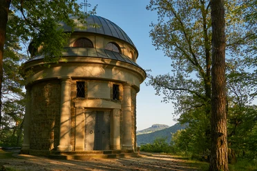
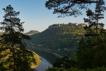
From the parking lot (or from the "Thürmsdorf Gasthaus" bus stop) below Thürmsdorf Castle, after a short climb we soon reach a wide gravel hiking trail, which initially leads slightly uphill and later relatively flat to the Biedermann Mausoleum. From here, a beautiful view opens up towards the town of Königstein on the Elbe and the fortress towering above it. A short detour to the Johann Thielemann viewpoint approx. 50 m further north-east is still worthwhile, as the path there is well developed. Walkers can now hike back along the same path. However, the tour itself runs from the junction about 100 m before the views, first on a field path that is easy to roll on, then on an old paved path to the road between Thürmsdorf and Weißig. We have to follow this road to the left for approx. 900 m before a wide footpath takes us to the romantic castle park and castle pond. (We do not recommend taking the shortcut to the castle pond approx. 200 m before the junction if you are in a wheelchair). The walk back to Thürmsdorf Castle is not difficult. Shortly before arriving, a short detour to the castle garden, where the statue "Adoratio - Adoration" is located, is highly recommended.
Tour information
Loop Road
Directions & Parking facilities
Drive from Pirna via Struppen to Thürmsdorf, the castle and the adjacent parking lot are located in the middle of the village on the left-hand side.
Medium-sized parking lot directly below the castle.
Arrival and departure: Bus route 241
Author´s Tip / Recommendation of the author
Also worth seeing: the sculpture "Adoratio - Adoration" in the park of Thürmsdorf Castle, which was created in 1907 by the Norwegian-Danish sculptor Stephan Abel Sinding
As a "reward", we recommend a stop at the chocolate café in Thürmsdorf Castle
Safety guidelines
The paths are well developed, but an accompanying person who can provide support if necessary is recommended. If you would like to complete the tour as suggested, you will have to walk approx. 900 m on an asphalted public road. There is no alternative for this section.
Nearby

Download GPX file