Bad Schandau - Schrammstein viewpoint - Breite Kluft - Bad Schandau


- 4:30 h
- 13.61 km
- 454 m
- 454 m
- 118 m
- 398 m
- 280 m
- Start: Bad Schandau
- Destination: Bad Schandau
Market square Bad Schandau - Hotel Lindenhof - Badallee - Lutherweg - Luther monument - Lutherweg - panoramic path - Ostrauer passenger lift - Ostrauer Ring - Falkensteinstraße - Klüfftelweg junction - Zahnsgrund - staircase ascent through Lattengrund - Schrammstein Gate - Wildschützensteig - Schrammstein viewpoint - Schrammstein ridge path - “Breite Kluft” junction - Elbleitenweg - Schrammstein viewpoint towards Obrigensteig - Elbe shore Bad Schandau

Good to know
Best to visit
Directions
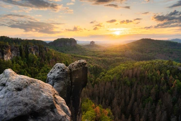
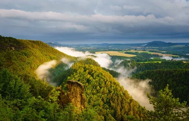
The route starts at the market square in Bad Schandau, the spa town in the heart of Saxon Switzerland. You follow the federal highway B172 a little eastward and then turn at the intersection where you meet the Hotel Lindenhof into Badallee. Shortly after, the staircase ascent of the Lutherweg appears on the right. After mastering the stone stairs, the Luther monument awaits you, which was erected in 1817 on the occasion of the 300th anniversary of the dissemination of Martin Luther's 95 Theses. Keep right on the Lutherweg, which leads you on a panoramic path past the Ostrauer passenger lift. After passing the Lutherweg, follow the Ostrauer Ring and then turn onto Falkensteinstraße. Via the Klüfftelweg junction, you reach the Zahnsgrund and then cross the KB740. On the opposite side, follow the staircase ascent through the Lattengrund. Continue past the spectacular Schrammstein Gate via the Wildschützensteig, which is peppered with numerous steep iron ladders, to the breathtaking Schrammstein viewpoint. Please note that the Wildschützensteig is only suitable for sure-footed and non-fearful hikers. Via the Schrammstein ridge path, you reach another large plateau with a phenomenal view over more iron ladders and bridges, inviting you to linger and rest. At the junction “Breite Kluft” it goes down again, past the striking 40 m high Devil's Tower, considered the symbol of “Saxon mountaineering.” You follow the Elbleitenweg for quite a while and then turn again to the Schrammstein viewpoint towards Obrigensteig. This leads you to the Elbe shore, which leads you back westward to Bad Schandau.
Tour information
Loop Road
Stop at an Inn
Equipment
sturdy footwear required
Directions & Parking facilities
From Dresden, take the A17 to Pirna, then B172 via Königstein to Bad Schandau. The border crossing to the Czech Republic at Hrensko – Decin is also signposted – onward travel to Prague is possible.
P+R at the National Park station, Elbe, Elbe bridge, Kiefricht, Lindenallee, tram stop
Arrival / Departure:
You can reach Bad Schandau by train S-Bahn line S1 every half hour from the state capital Dresden.
The Bad Schandau station is directly connected to the town center by a Elbe ferry (so-called longitudinal ferry). The optimal arrival is by S-Bahn via the Krippen stop (one station before Bad Schandau).
Literature
Order now: Hiking guide
Author´s Tip / Recommendation of the author
Don't forget your camera! Suitable only with small, portable dogs
Safety guidelines
Difficult, demanding terrain, numerous stairs, bridges, and iron ladders
Please note: in the Saxon Switzerland National Park, only marked paths may be used in the core zone! Violations may result in fines.
Map
Nearby


Download GPX file