Cunnersdorf circular route to the Katzstein


- 3:00 h
- 8.95 km
- 284 m
- 289 m
- 243 m
- 463 m
- 220 m
- Start: Cunnersdorf
- Destination: Cunnersdorf
Route: Cunnersdorf - Alte Rosenthaler Straße - Spitzstein - Katzstein - Signalaussicht - Cunnersdorf

Good to know
Pavements
Street (2%)
Asphalt (2%)
Gravel (12%)
Trail (49%)
Path (34%)
Best to visit
suitable
Depends on weather
Directions
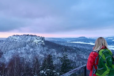
The destination of this tour is a rather quiet vantage point in the left bank of Saxon Switzerland - the Katzstein. From Cunnersdorf, the trail first leads south. Once you have reached the spruce thicket, it is not far to the first rock of the tour - the Spitzstein. The nearby Spitzstein bivouac offers a wonderful opportunity for a short rest. From there, continue to the Schneebergblick. The view on the south side of the Katzstein is one of the most beautiful in the Elbe Sandstone Mountains: 180 degree unobstructed views - from the Schrammstein range to the Hoher Schneeberg. From here, the route continues northwards across the wooded plateau of the Katzstein to the Signal viewpoint - past the Katzfels, probably the smallest viewpoint in Saxon Switzerland. From there, the descent back to Cunnersdorf begins.
Tour information
Loop Road
Summit
Equipment
- Onion-skin clothing and winter hiking boots
- Backpack with hiking map, snacks, thermos flask with a warm drink, smartphone, flashlight, first aid kit
- Hiking poles, ice goggles
Directions & Parking facilities
Cunnersdorf cemetery
from/to Cunnersdorf: Bus 244
Timetable information: www.vvo-online.de
Additional information
Things to know about winter hiking in Saxon Switzerland
Author´s Tip / Recommendation of the author
Safety guidelines
This tour is a red route (medium difficulty).
The hiking trails are not cleared of ice and snow. Please refrain from the winter hike in icy conditions.
Map
Winter hiking map Saxon Switzerland
Edition with 40 winter hiking routes including winter catering
Nearby


Download GPX file