Malerweg Trail – Stage 5
Here you will learn about the rich local heritage of historic mills, climb the second-highest mountain of Saxon Switzerland and experience Germany’s first eco-village.
Current weather in Saxony
Weather tips
Here you will learn about the rich local heritage of historic mills, climb the second-highest mountain of Saxon Switzerland and experience Germany’s first eco-village.
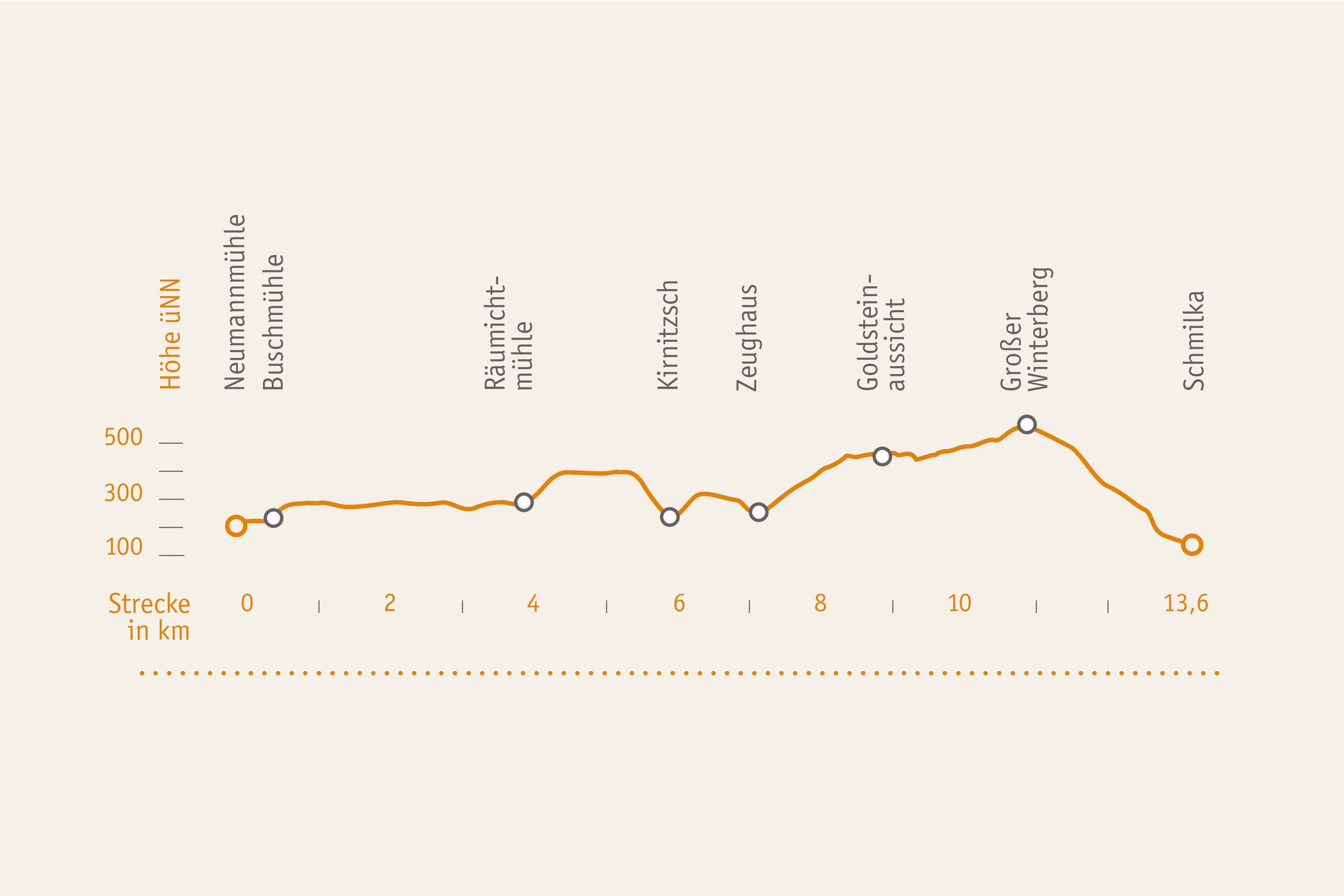
The fifth Malerweg Trail stage is 13.6.km long. There are no catering facilities on the route.
For the 5th Malerweg Trail stage you should plan seven hours plus extra time for detours and breaks.
UPHILL. The fifth stage is challenging and requires a good fitness level. Winterberg is the second-highest mountain in Saxon Switzerland.
DOWNHILL. There are several downhill sections on this stage. The most strenuous descent is from Großer Winterberg Mountain down to Schmilka Village.

Route Description
The Malerweg Trail starts at Neumannmühle Museum Mill and leads first up the Kirnitzsch Stream to Buschmühle Mill. There you turn left and continue in the direction of Arnstein Rock on a path called Neuer Weg, to a turn-off marked “Abzweig Kleinstein” and further on to a road which you then follow until Räumichtmühle Mill. On the opposite side of the road you continue uphill on a path called Mühlschlüchte and then downhill again to the Kirnitzsch Stream and further on to the Zeughaus. From there the trail runs uphill via paths named Wolfsschlüchte, Roßsteig and Katzsteig to the summit of Großer Winterberg Mountain (556 m). Great, you made it! For the rest of this day you will only walk downhill now. The destination for this stage is the National Park eco village resort of Schmilka with its lovely location in the Elbe Valley.
Accommodation along the Malerweg Trail
Hosts listed on this page are certified as “Hiker-friendly at the Malerweg Trail”; they are prepared for Malerweg trail hikers. If you are looking for hotels, guest houses, hostels or camp sites along the fifth stage only, click on this button. Note: Connecting trails will take you to/from hosts in Hinterhermsdorf. This will extend the stage by 2-3 km.
Detailed route descriptions with maps and GPS data are available here:
Connection route to the Malerweg Trail from Hinterhermsdorf Village to Mühlschlüchte Path (2,7 km | 1 h)
Hinterhermsdorf/Dorfplatz (village centre) – Oberer Hirschewaldweg Path (green bar) – Mühlschlüchte Path (green bar) – Malerweg Trail.
Connection route to the Malerweg Trail from Sebnitz to Neumannmühle Mill (8 km |3 h)
Sebnitz, Marktplatz (Market Square)– Hertigswalder Straße Road – Hubenberg Hill – Sauers Ruh (Sauer’s Rest) – Panoramaweg Trail to turn-off »1. Kurve« (red bar) – then following yellow dot to Lichtenhain Village – (green dot) – Knechtsbach Brook – Knechtsbachtal Gorge (yellow bar) – Flößersteig (Floaters Trail) to Neumannmühle Mill– Malerweg Trail.
Note: The stage is extended accordingly to 16.3 km (from Hinterhermsdorf) and 21.6 km (from Sebnitz).
Arrival to fifth stage:
Bus No 241, bus stop “Neumannmühle”
Departure from 5th stage:
Bus No 252, bus stop: „Schmilka, Grenzübergang“
Ferry Schmilka; S-Bahn Train S1, National Park Railway U28 train stop “Schmilka-Hirschmühle”
Wanderschiff (Hiking Boat)
Tourist information point Hinterhermsdorf
Haus des Gastes
Weifbergstr. 1
01855 Sebnitz OT Hinterhermsdorf
fon:+49 35974 5210
Touristinformation Bad Schandau
Haus des Gastes
Markplatz 12
01814 Bad Schandau
fon: +49 35022 90030
oder
Aktiv Zentrum Sächsische Schweiz
im Hotel ELBRESIDENZ
Markt 1-11
01814 Bad Schandau
fon: +49 35022 90050
It should be no problem to walk this stage with a dog.
Here you find out which artists are related to the fifth Malerweg Trail stage and which of the free collectable picture postcard motifs is available along this stage.
Recommendations on the 5th Stage of the Malerweg
“Zeughaus” National Park Information Point
The old Zeughaus building, a former foresters’ lodge, houses another National Park information point. It focuses on the subject of historic game hunting such as capercaillie, lynx, wolf and stag. The Zeughaus also has toilet facilities, by the way.
Schmilka Information Point
The end of the 5th stage is Schmilka Village. As soon as you come across the first buildings, you can find a National Park information point to your right which provides interesting information about mountaineering in Saxon Switzerland. Climbing was in fact done as a sport for the first time in the Elbe Sandstone Mountains and so, the area is considered to be the birthplace of free climbing. In the exhibition you learn more about the compatibility of mountaineering and nature protection.
Nationalpark-Informationspunkt Schmilka
Schmilka Nr. 53
01814 Bad Schandau OT Schmilka
Detours and Highlights along the Malerweg Trail
Arnstein Rock
Arnstein Rock is colloquially known as the Ottendorfer Raubschloss (robbery castle). The remains of one of the area’s oldest forts (15th century) are a cistern, stairs, rock cramps and even a petroglyph. This legendary place also provides a wonderful view in particular in the morning hours.
(Distance1 km | 30 min)
Kleinsteinhöhle Rock Cave
It is definitely worth the detour to the second-largest rock arch of Saxon Switzerland. Further uphill is a look-out point providing more perspectives.
(Distance 0.2 km | 10 min)
Großes Pohlshorn Rock
The impressive view from the summit of the extended Pohlshorn Rock formation justifies all the efforts of the detour. With a sharp eye, you can discover Kleinsteinhöhle Rock Cave from here and also the next days’ destinations of your Malerweg Trail hike.
(Distance 0.2 km | 8 min)
Goldstein View
From this look-out point you enjoy a wonderful wide view to Outer Saxon Switzerland. In summer this is an ideal picnic spot, while in autumn, the foliage colouring is awe-inspiring and in winter the details of the rock structures are particularly visible. Here you are in the heart of the National Park and can glimpse true unspoilt nature.
(Distance 0.2 km | 8 min)
Großer Winterberg Mountain
With its altitude of 556 m Großer Winterberg Mountain is the highest elevation on the right bank of the Elbe River. At its summit is a National Park information point (Eishaus), a look-out tower and a cosy restaurant and hotel. Please note that the Eishaus, the look-out tower and also the hotel are closed for the time being.
Kipphorn Cliff View
Near Winterberg Mountain a detour to the Kipphorn Cliff View (480 m) is very worthwhile. From here, a grand panoramic view opens up over Saxon and Bohemian Switzerland. The motif is particularly popular among photographers at sunset.
(Distance 0.4 km | 10 min)
Schmilka Village
Schmilka Village is situated at the border with the Czech Republic at the edge of the National Park. Before reaching the Elbe River, hikers find a National Park information point here and a refurbished mill including a bakery. Schmilka Village belongs to the town of Bad Schandau and is accessible by the S-Bahn train, bus and ferry.
Little Bastei Rock
If you are not too worn out after your long Malerweg Trail hike, a climb up to a look-out point called “Kleine Bastei” (Little Bastei Rock) is worthwhile. It is a wonderful place to enjoy the sunset while admiring views to the Elbe River and to the Schrammsteine Rock formations. For the descent over stairs and steps, torchlight is helpful.
Bad Schandau
The health resort Bad Schandau is located in the centre of the area. The small town with its typical medieval centre is a great place to browse the cafés, restaurants and boutiques. A visit of the National Park Centre or of the “Toskana-Therme” Spa is worthwhile, too.
(Distance 6 km | 1.5 h)
It appears that you are using Microsoft Internet Explorer as your web browser to access our site.
For practical and security reasons, we recommend that you use a current web browser such as Firefox, Chrome, Safari, Opera, or Edge. Internet Explorer does not always display the complete content of our website and does not offer all the necessary functions.


