Through lonely forests to rocky viewing platforms


- 4:15 h
- 14.22 km
- 489 m
- 489 m
- 244 m
- 463 m
- 219 m
- Start: Bus stop Cunnersdorf Schmiede
- Destination: Bus stop Cunnersdorf Schmiede
Cunnersdorf – Spitzer Stein (Spitzstein) – Neuteich – Lampertstein – Neuteich – Pechloch – Katzstein – Signal – Cunnersdorf

Good to know
Pavements
Best to visit
Directions
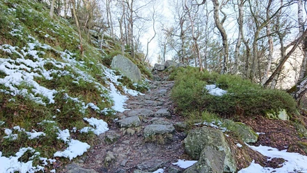
From Cunnersdorfer Straße, we turn slightly uphill to the right and follow the marking "yellow line." After leaving the houses of Cunnersdorf behind us, the road turns into a field path and later into a forest path. The last meters to the Spitzen Stein we climb steep steps to finally reach the 410m high rock via an iron ladder.
The development of Spitzen Stein with simple wooden ladders took place in 1885. Only about 100 years later were the iron climbing system and the railing built. From here, there is a wonderful panoramic view of the table mountains of Saxon Switzerland.
After this detour, we continue hiking (marking "yellow line") to the Spitzstein bivouac and on the Root Path. Now you have to be careful not to miss the turnoff onto a small path to the right about 400 meters from the Spitzstein bivouac! At the turnoff, there is a post with the forest trail marking (yellow vertical line). After descending to the Neuteich, we continue on the forest trail (yellow line) towards Lampertstein. The promenade winds along beneath the rock walls until we reach the steps up to the Lampertstein and go right to the viewpoint.
Lampertstein is named after its former owner according to an older tradition. From here you can see Königstein, Lilienstein, Pfaffenstein, Gohrisch, Papststein, Falkenstein, Schrammsteine, and as far as Großer Winterberg.
For the return route, we choose the ridge path, take in the viewpoint "Schneeberger Blick", and after about 200m leave the forest trail. A small path turns sharply left, and we follow the marking "yellow line" towards Katzstein. Once back on the "promenade," we take the same way back towards Neuteich. From here, we hike uphill on the Pechweg (paved forest road) until we cross the wide forest road "Root Path." There is a covered resting place there. Then we continue straight on the hiking trail "Pechloch." The higher we get, the narrower and steeper this path becomes. The signpost says "Connection (green dot) to Katzstein and Signal." Upon reaching the Mäusebornweg ("green dot"), we turn left and, following the signs of the forest trail, continue to Katzstein (iron ladder to the viewpoint) and to the Signal.
It is assumed that this was once the territory of numerous wildcats. The last specimen was killed in this area near the border in 1809. A steep ladder (only for those not afraid of heights) leads up to the narrow rock (474 m) of Katzstein. In clear weather, you can see the faraway Unger and Tanzplan, somewhat closer the Kohlbornstein, the Laasensteine, Schrammsteine, Winterberg, Zirkelstein, Kaiserkrone, and very close the small and large Zschirnstein.
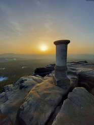
The Signal is the viewpoint on the north side of the Katzstein massif. It had an important function as an observation post of the Royal Forest Administration for possible forest fires.
After descending from the Signal, we reach a seating area and the marking "green dot" again. We follow the Spitzsteinweg to the right until the Winterleitenstraße intersection. From here, we hike back on Winterleitenstraße (marking "red line") to Cunnersdorf, the starting point. Those wanting to go to the Waldbad Cunnersdorf continue straight along the marking "green dot." From the Waldbad to the starting point of the hike is about a 15-minute walk along the street into the town of Cunnersdorf.
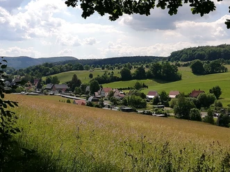
The settlement of most villages in Saxon Switzerland took place in the 12th century. Settlers from Lower Saxony, Thuringia, and Franconia set out and also founded the village of Cunnersdorf. It can be assumed that the locator was named Konrad. From this, the village name "Kunradsdorf" (1379) and "Connersdorffe" (1539) developed into Cunnersdorf.
Tour information
Loop Road
Summit
Tour with Dog
Equipment
Hiking shoes and provisions
Directions & Parking facilities
Very few parking spaces (approx. 8) opposite the Cunnersdorf Church (free of charge): To reach the starting point of the hike, go to the intersection of Cunnersdorfer Straße and turn left there. After a few meters, you will reach the signposts.
Additional information
Infos zum Waldbad Cunnersdorf (Ein Besuch im Waldbad lässt sich gut mit der Tour verknüpfen, jedoch bleibt in der Saison 2026 das Waldbad wegen Baumaßnahmen geschlossen und ist daher in der Tourbeschreibung nicht enthalten.)
Author´s Tip / Recommendation of the author
On hot summer days, a visit to the Waldbad Cunnersdorf is worthwhile. Pack your swimwear!
The route is suitable for older, enthusiastic children and also for dogs.
Safety guidelines
Nearby


Download GPX file