Cunnersdorf: To the highest mountain of Saxon Switzerland - Großer Zschirnstein


- 6:15 h
- 21.81 km
- 564 m
- 564 m
- 250 m
- 549 m
- 299 m
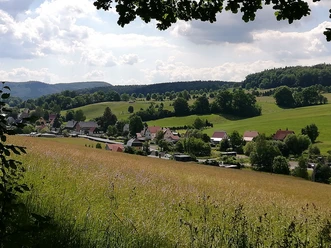
- Start: Cunnersdorf / Bus stop Deutsches Haus
- Destination: Cunnersdorf / Bus stop Deutsches Haus
Bus stop Cunnersdorf - Lindhornweg - Cotta Oak - Sandy Path - Matthias-Otto Oak - Forest Road "Alte Drei" - Lindhornweg - Gebackene Birnenstraße - Forest Road (T-Weg) - Meadow Path - Kalkbude - Zschirnsteinweg - Großer Zschirnstein - Wildbretkeller - Schifferweg - Hertels Born - Krippenbachweg - Furtweg - Forest Road "Lange Fünf"- Lindhornweg - Bus stop Cunnersdorf

Good to know
Best to visit
Directions
From the bus turning loop (at the hotel "Deutsches Haus") in Cunnersdorf, we follow the "green dash" mark on the Lindhornweg. Initially, the Lindhornweg is a paved, narrow road, later becoming a gravel forest road that steadily climbs uphill and then transitions into a grass-covered forest path. After about 3 km, we reach a covered resting place. About 50 meters from here, you can admire the Cotta Oak. It owes its name to Heinrich Cotta, the founder of the Tharandt Forest Academy, and his son, who worked as a geologist and mining scientist.
Back at the resting place, we continue following the "green dash" mark and arrive via the sandy path at the next large oak - the Matthias-Otto Oak. To reach the Stolzenhain Deserted Village, we want to take a small detour and leave the green mark. The wide forest road "Alte Drei" takes us back to the Lindhornweg. To the right is a small shelter, and opposite we find a signboard indicating where the lost village of Stolzenhain is said to have been located. We immediately turn right off the Lindhornweg onto an unmarked forest path and continue straight until we meet the Gebackene Birnenstraße. We continue again with the "green dash" marking until we reach the spot where the Kühler Morgen Deserted Village is said to have been (signboard). For a long time, it was believed that until the Thirty Years' War, a village stood here that was wiped out by the plague. The term may also simply refer to a clearing the size of a "Morgen" (an old area measurement, about a quarter of a hectare).
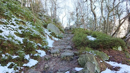
Now we turn left, leave the marked hiking trail, but stay on the Gebackene Birnenstraße. When we reach the next wide forest road (T-Weg), we cross it and walk straight ahead until we reach the German-Czech border. Various boundary stones and the marking of the forest path (yellow vertical dash) show us the way, which we follow to the left. Now follow several steep ascents and descents on the border path, past small streams and springs, until the forest path sharply turns left. At the Zschirnstein bivouac, you can take a break.
Here, we leave the forest path and continue along the meadow path (marking "yellow dash"). At the overgrown junction to the Old Market Way, you can discover a historic way column ("The Hand") from 1840. At the next intersection (Kalkbude), we turn left and hike uphill on the Zschirnsteinweg (marking "red dot"). The forest path soon turns left, but we continue a bit further until the next path branches off to the left. The signpost says "Powder Chamber", which we discover after about 100 meters on the left by small rocks. Here, the gunpowder used in the basalt quarries was stored. Basalt was quarried in the 19th century until about 1920 and used as road gravel.
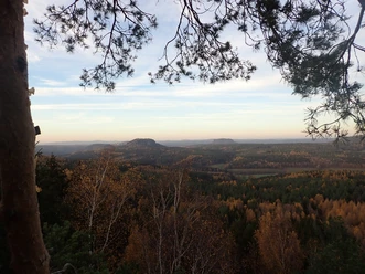
We continue this path; the forest path joins from below, which we now follow up to the summit of the Großer Zschirnstein. Various viewpoints and a hut invite you to rest. The triangulation column, erected in 1865 as part of the Saxon State Survey, marks the highest point of the Saxon Switzerland.
For the descent from Großer Zschirnstein, we choose the wide hiking trail (marking "red dot"), past the former basalt quarry, then turn left towards Kleingießhübel. Further down, we can take a look into the Wildbretkeller before continuing left on the Schifferweg (marking "green dot"). At the Hertels Born spring, we can refresh ourselves once again.
Arriving in Krippental, we walk the paved forest road to the left, past another spring (Furtborn), and shortly afterwards turn left onto the Furtweg (marking "green dot"). Here it goes steeply uphill once more until we meet the forest road "Lange Fünf" and turn right. We continue to follow the "green dot" marking – a short section of road, parking lot, and along the forest edge – until we reach the Lindhornweg again. The "green dash" mark leads us back to Cunnersdorf.
Tour information
Cultural Interesting
Loop Road
Summit
Tour with Dog
Directions & Parking facilities
Plan your journey with Google Maps: https://goo.gl/maps/tp3vwNmb5zvxqtmK8
In Cunnersdorf, park at the Erbgericht. Walk along the street towards Waldbad Cunnersdorf to the starting point of the hike. Continue along the Lindhornweg at the bus turning loop.
Additional information
Here you find everything about hiking in the Elbe Sandstone Mountains.
All our hiking routes with free GPX download can be found directly on our website.
Author´s Tip / Recommendation of the author
This route is rather not suitable for children due to its length, but suitable for energetic dogs.
Safety guidelines
There is no opportunity to stop for food during the long hike. Bring enough provisions!
Map
Order here: Hintere Sächsische Schweiz Blatt 1
Nearby


Download GPX file