Three in one go


- 3:55 h
- 11.94 km
- 403 m
- 403 m
- 204 m
- 413 m
- 209 m
- Start: Bus stop Eiche, Hohnstein
- Destination: Bus stop Eiche, Hohnstein
Hohnstein/bus stop "Eiche" or parking lot - Napoleonschanze - Tiefer Grund - Waitzdorfer Höhe (414m) - Waitzdorfer Schänke - Dorfgrund - Tiefer Grund - Brandstufen - Brandaussicht - Hohnstein

Good to know
Pavements
Best to visit
Directions
As we ascend, we can already see the Lilienstein and Königstein Fortress; at the highest point of the Napoleonschanze, the Rauenstein, the Bärensteine and the Bastei also stand out clearly on the horizon. The Napoleonschanze (also known as "Schanzenberg") is an artificial earth embankment up to 4 meters high, which had to be built in 1813 by the inhabitants of the Hohnstein-Lohmen district under the most difficult conditions in order to secure the Napoleon road from Königstein Fortress to Stolpen Castle. One day after its completion, the French army took up position. This was followed by battles with heavy losses on both sides of the war. After Austria allied itself with the Russians and Prussians against the French and Saxon troops in August 1813, Napoleon's defeat was sealed with the Battle of Leipzig.
After visiting this historic site, we turn right downhill across the meadow and turn left just before the edge of the forest. The path leads into the forest, at the next signpost we turn left towards Waitzdorf and follow the green line markings (Ringflügelweg). As you walk, you can see the natural regeneration of the forest in the form of young beech and spruce trees replacing their predecessors that have died due to bark beetle infestation. At the next crossroads, keep straight on (yellow line) in the direction of Waitzdorf. The Brandweg leads us in gentle serpentines down into the valley of the Tiefen Grunds.
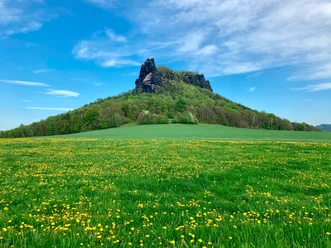
We cross the road and follow the Holländerweg up to Waitzdorf, where the scent of farming wafts into our nostrils - Galloways, sheep, horses and goats graze in the vicinity of the village of 50 inhabitants. We now take a detour to the Waitzdorfer Höhe (414 m), turning left at the second bench onto the Leichenweg. Once at the top, a seating area invites you to take a break. A board also shows us which mountains can be seen in the distance. The imposing Lilienstein with its striking western edge is particularly impressive, but the Zschirnsteine, Laasensteine, Kohlbornstein, Kleinhennersdorfer Stein, Gohrisch and Papststein also stand out clearly. At 722 meters above sea level, the Schneeberg is the highest point on the horizon. The descent leads along the meadow, opening up views of the Schrammstein chain.
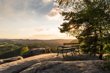
Back on the Holländerweg, we turn left. We soon reach the Holländerweg bus stop and turn right into the street "Am Dorfgrund" (Malerweg). The Waitzdorfer Schänke invites you to stop for a bite to eat. Shortly after the small pond, we turn left into the Dorfgrund, which leads us down steps into the Tiefen Grund. We walk down the road for approx. 300 meters before climbing steeply up the Brand steps (right, blue and red line, Malerweg) to the "Balcony of Saxon Switzerland" - the Brandaussicht. From the exposed viewing area, you can enjoy a panoramic view from the Schrammsteine in the east to Rathen in the west! The Brand-Baude offers another refreshment stop.
A visit to the Blockhaus Brand national park information point is a good idea. Interesting information about the mountains, waters and sights on display can be accessed via interactive screen presentations. You can also find out more about the Polenz Valley and its special features. The "children's corner" of the exhibition entices visitors with a foray into the world of birds. Children can learn how our native bird species are tied to very specific habitats in a playful way on the screen and with the help of animal specimens.
For the short way back to Hohnstein, we follow Brandstraße until the green line junction, where we turn left, later pass a small pond and after a few minutes come to the path with the red line markings. Turn right here. At the next crossroads, we continue straight ahead and soon arrive back in Hohnstein. Via Brand- and Max-Jacob-Straße, we return to the starting point of the hike - Hohnstein Eiche.
[GPS updated 2026]
Tour information
Cultural Interesting
Loop Road
Stop at an Inn
Summit
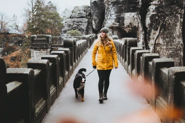
Tour with Dog
Equipment
Directions & Parking facilities
Additional information
Website of the Brand-Baude: https: //www.brand-baude.de/
- All the rules in the national park
- Tips for safe hiking in Saxon Switzerland, created in cooperation with the mountain rescue service
- Tips on dealing with dead wood for hikes, especially through dead spruce stands
Author´s Tip / Recommendation of the author
Safety guidelines
Please note: The majority of the tour runs through the Saxon Switzerland National Park. Here you are not allowed to leave the paths and dogs must always be kept on a lead. In the core zone (recognizable by signs in the area), only marked paths may be used. Fines may be imposed for non-compliance.
Further information about the national park, for example about the rules that apply there and the path markings, can be found on the national park website.
Nearby


Download GPX file