The Conquest of Königstein Fortress


- 5:30 h
- 9.47 km
- 328 m
- 327 m
- 116 m
- 361 m
- 245 m
- Start: Königstein/Reißiger Platz
- Destination: Königstein/Reißiger Platz

Good to know
Best to visit
Directions
Starting from Königstein train station or the parking lot, first cross the busy B172 at the pedestrian traffic light. From Reißiger Platz (bus stops), we walk past the town church of Königstein. Behind the church, our ascent begins on the Harald-Schurz-Weg. The path is marked with "blue stroke" and "Malerweg". After just a few meters on the old sandstone-paved path, the view opens to the opposite Lilienstein and the town of Königstein. We continue over some steps through the forest until we reach the edge of a large meadow, from which we can see Pfaffenstein. Passing by the Palmschänke (no longer in operation), the path soon widens. At a fork, we choose the right path ("blue stroke"; Malerweg) leading to the mighty fortress wall. Directly below the fortress wall begins the patrol path at the parking lot, which we walk counterclockwise.
The patrol path was laid out in the 19th century. The guards now had the wooded slope in close view—this promised more security in case of war but also made escape more difficult for prisoners of the fortress.
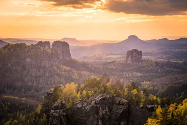
Impressive are the high, smoothly polished rock walls, the various towers and buildings visible from below, and the natural rock formations such as chimneys (Abratzky chimney), cracks, and weathering. After about 1.5 km, the fortress is circumnavigated at the foot, and we climb the wide paved path through the mighty Medusa Gate, over the drawbridge, and the long, dark ramp ("Dark Apparatus") up onto the plateau of Königstein Fortress. There is so much to discover here that a guided tour or renting an audio guide is highly recommended!
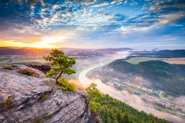
Königstein Fortress is considered one of the largest mountain fortresses in Europe and lies on the eponymous table mountain above the town of Königstein. The 9.5-hectare rock plateau rises 240 meters above the Elbe. Over 50 buildings, some over 400 years old, testify to the military and civilian life on the fortress. The medieval castle belonged to the Kingdom of Bohemia. The first complete designation “Königstein” occurred in the Upper Lusatian border deed of 1241, sealed by Wenceslaus I. “in lapide regis” (Latin: on the king’s stone). The exhibition of the same name vividly presents the history of Königstein Fortress. There are also many exciting exhibits for children to try out and touch. Numerous buildings and exhibitions can be visited, such as the Magdalenenburg, which housed August the Strong's giant wine barrel in the 18th and 19th centuries. Particularly impressive is the castle well, the second deepest in Europe at 152.5 meters. In the well house, you can experience a demonstration of the water pumping system.
We return down the same way or by elevator. Now the Malerweg and the “red dot” marking lead towards Königstein/Thürmsdorf. Soon we reach the Old Fortress Road. If you take it to the right, you are back in Königstein in 15 minutes. We decide to follow the Old Fortress Road to the left (Malerweg). Soon we reach a large meadow. Looking back, you have a wonderful view of the fortress and Lilienstein. Continuing on the Malerweg, we pass underneath the B172 through a pedestrian tunnel, cross the road leading to Struppen, and arrive at the historic Cannon Path (marked "yellow stroke"). This path descends towards Königstein.
The Cannon Path has existed since the 17th century. To transport heavy goods such as cast-iron cannons up to the fortress, it was necessary to create a gentler ramp through the steep Elbe slope. In the upper part, you can still discover the old paving.
From Elbhäuserweg, which runs parallel to the railway, there is a good view of the Elbe. Now it is not far until you reach the starting point of the hike—Königstein—again.
Tour information
Cultural Interesting
Loop Road
Stop at an Inn
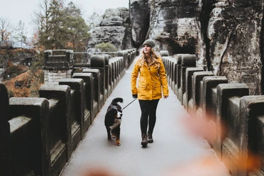
Tour with Dog
Directions & Parking facilities
Author´s Tip / Recommendation of the author
Dogs and children can easily participate in this hike.
Entrance to Königstein Fortress requires a fee! Please observe the opening hours of Königstein Fortress.
Nearby


Download GPX file