Malerweg Trail Stage 3
The “Balcony of Saxon Switzerland“ with its famous panoramic view, an idyllic mountain village and a picturesque valley are the highlights of the Malerweg trail’s 3rd stage.
Current weather in Saxony
Weather tips
The “Balcony of Saxon Switzerland“ with its famous panoramic view, an idyllic mountain village and a picturesque valley are the highlights of the Malerweg trail’s 3rd stage.
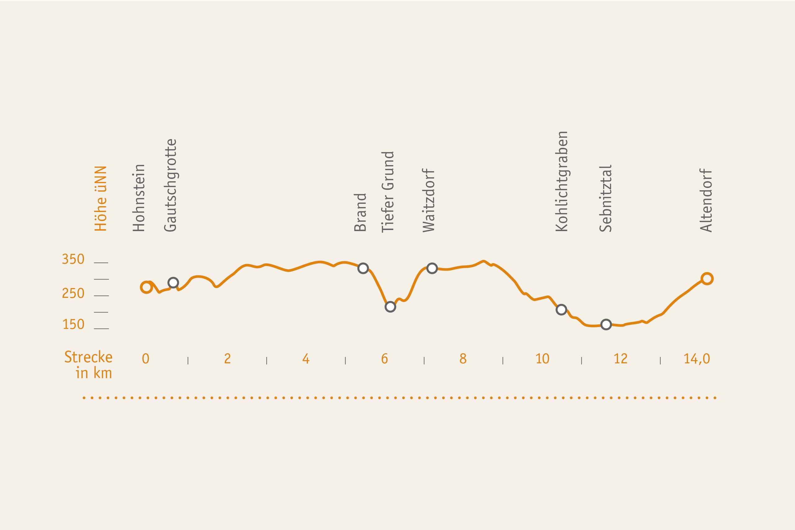
The third stage of the Malerweg Trail stretches over 14 kilometres and is marked by two considerable altitude changes.
The walking time needed for the third stage in an average hiking pace is at five and a half hour not including detours and breaks.
UPHILL. The 3rd stage has a moderate degree of difficulty and thus should be manageable without problems for people of an average fitness level used to occasional hiking.
DOWNHILL: The lowest point is leisurely to be reached in Sebnitztal valley. The most strenuous sections are the steps down from the Brand Rock and then on the other side up again to Waitzdorf Village.

Route description
The starting point is in the fortress town of Hohnstein. The trail leads first downhill to the Bear Garden. Only a few picturesque walls remain of this former game reserve. The trail continues in the woods along paths named “Halbenweg” and “Räumichtweg” in the direction of the Brand Mountain viewing point. The view from Brand Mountain in fact belongs to the region’s most famous sights. From Brand Mountain the trail runs down over more than 800 steps to a canyon-like valley called “Tiefer Grund”, then after 300 metres turns right into “Dorfgrund” Gorge and runs uphill to the peaceful village of Waitzdorf. Following the Waitzdorf loop route the trail continues on the “Mühlweg” Path and finally onto the wildly romantic “Kohlichtgraben” Path. Following the brook you reach a small hamlet, Kohlmühle, where a mysterious huge brick building faces you, in fact an abandoned linoleum factory. From Kohlmühle Village the trail continues in the valley of the Sebnitz Stream to its confluence with the Schwarzbach Brook and then along Mühlweg Path to the destination of this stage, Altendorf Village.
Accommodation along the Malerweg trail
Hosts listed on this page are certified to be “Hiker-friendly on the Malerweg Trail”, they are prepared for Malerweg trail hikers. If you are looking for hotels, guest houses, hostels or camp sites along the third stage only, click on this button.
Detailed route descriptions with maps and GPS data are available here:
Connection route to the Malerweg Trail from Neustadt into Sebnitztal valley via “Götzingerweg” trail (11.4 km/4 h)
Neustadt, Promenadenweg path – Kneipp water facility (red bar), passing Götzinger Höhe view point – Stadtwald (municipal forest), continuing to junction marked with yellow bar – villages of Krumhermsdorf – Neuhäuser – Lohsdorf – Schwarzbachtal Valley – Sebnitztal Valley– Malerweg Trail.
Arrival to third stage:
Busses 236, 237; bus stop: „Hohnstein, Polenztal“
Busses 236, 237, 254, 264; bus stop: „Hohnstein, Eiche“
Malerweg trail shuttle service für Hohnstein area:
Phone: +49 35975 86813
Departure from 3rd stage:
U28 National Park train, train stop: Goßdorf-Kohlmühle station
Bus 260; bus stop „Altendorf Erbgericht“
Tourist information point Hohnstein
Rathausstr. 9
01848 Hohnstein
fon: +49 35975 19433 or fon: +49 35975 86813
Tourist information point Altendorf
Sebnitzer Str. 2
01855 Sebnitz OT Altendorf
fon: +49 35022 42774 or fon: +49 35022 50372
Tourist information point Bad Schandau
Haus des Gastes
Markplatz 12
fon: +49 35022 90030
Aktiv Zentrum Sächsische Schweiz
im Hotel ELBRESIDENZ
Markt 1-11
01814 Bad Schandau
Tel.: +49 35022 90050
This stage should be manageable for dogs without any problems.
Here you can learn which artists are linked to the third Malerweg Trail stage and which motif of the collectible postcards you can take along free of charge from this stage.
Recommendations on the 3rd Stage of the Malerweg
National Park Information Point “Brand Mountain Log House” (Blockhaus Brand)
The historic log cabin situated at the fascinating Brand Mountain viewing point houses an information site for Saxon Switzerland National Park. A relief model gives a great overview of the rugged sandstone region. It was made by the well-known artist Irmgard Uhlig and renovated by the National Park administration a couple of years ago. Facts about local flora and fauna will help you roam the National Park region with your eyes wide open. It is worth taking a stroll in the exhibition.
Nationalpark-Informationsstelle "Blockhaus Brand"
Brandstraße 27
01848 Hohnstein
open all year round: 10 am – 17 pm
Free entry
Saxon Switzerland National Park Centre
The Saxon Switzerland National Park Centre in the town of Bad Schandau is the visitor centre of the protected area. How did this baffling rocky world come into being? Which rare animals live here? What is the ecological system in a forest habitat like? The museum informs about of all that with the help of numerous models in an illustrative and family-friendly style. One of the highlights is a multivision show in the cinema hall featuring fantastic images of the National Park area.
(distance of detour 2.5 km | 1 h)
Dresdner Straße 2 B
01814 Bad Schandau
Phone: +49 35022 50240
April to October: Monday – Sunday 9 am – 6 pm
November to March: Tuesday – Sunday 9 am – 5 pm
Detours and Highlights along the Malerweg Trail
Gautschgrotte Cave
The detour trail to “Gautschgrotte” rock cave is situated directly at the trail, but a little hidden. The boulders in front of it are covered by a lush carpet of green mosses and ferns. The cave itself is framed by an about 18 m high rock wall. At its edges dripping water freezes to interesting ice formations in winter.
(Distance: 100 metres | 3 minutes)
Napoleonschanze (Napoleon’s Redoubt)
A French entrenchment near the town of Hohnstein on Schanzenberg Hill dates back to 1813. At that time, an artificial earth wall was heaped up to a height of 3 to 4 meters and equipped with three gun emplacements in order to cover the Polenztal Gorge and thus the road running between Königstein Fortress and Stolpen Castle. Originally, this granite hilltop was called “Kretschelberg”.
(Distance: 2.1 km |1 h)
Waitzdorf
This small hamlet of only 50 inhabitants is situated directly in the National Park core zone (Kernzone) and belongs to the town of Hohnstein. Waitzdorf has a beeline distance from Brand Mountain of only 1 kilometre, but they are separated by the Tiefer Grund Ravine including 1600 steps.
From the nearby elevation called Waitzdorfer Höhe you have a really majestic panoramic view and the various look-outs directly along the Malerweg Trail are particularly spectacular.
Goßdorf Robbery Castle (Raubschloss)
The Goßdorf or Ulbersdorf Robbery Castle was first mentioned in a document in the 14th century. It is a ruin today; the remains of the former robber knights’ nest are still to be seen. Some excavations were made around 1800. Since time immemorial, many a legend and haunted story have been told about the castle.
(Distance: 1.2 km | 0.5 h)
Sebnitztal Valley
The small place Kohlmühle in the dreamy Sebnitz Valley has been a popular trip destination for more than 100 years. Kohlmühle Mill itself has existed since 1756. Eventually, the construction of a narrow-gauge railway made it possible to run a paper factory which later was used as a linoleum plant. The remains of the brickwork building are listed as a heritage site.
Altendorf and Adamsberg Hill
Altendorf Village is not far from the town of Bad Schandau, but it belongs to the municipality of Sebnitz. From this place, the view to the distant Schrammsteine Rock is absolutely fascinating. A short detour to Adamsberg Hill is worth the effort. Particularly in the afternoon and evening, the rock formations such as Schrammsteine, Falkenstein, Bloßstock and Langes Horn present a particularly appealing sight from here.
(Distance: 1.1 km | 0.5 h)
It appears that you are using Microsoft Internet Explorer as your web browser to access our site.
For practical and security reasons, we recommend that you use a current web browser such as Firefox, Chrome, Safari, Opera, or Edge. Internet Explorer does not always display the complete content of our website and does not offer all the necessary functions.


